Good morning. This is Dave Zinn with the Gallatin National Forest Avalanche Forecast on Wednesday, December 7th at 7:00 a.m. This information is sponsored by World Boards and Mystery Ranch. This forecast does not apply to operating ski areas.
Please consider donating to the Friends of GNFAC Annual Fundraiser.
*Note: Bridger Bowl Ski Area IS CLOSED TO ALL uphill travel as they prepare for Friday’s opening. It will remain closed to uphill travel for the duration of their season.
This morning, mountain temperatures are in the teens F with 20-30 mph winds from the west to southwest. Cooke City received 3” of snow in the last 24 hours with 1” near West Yellowstone. Today, the high temperatures will be in the upper teens F, winds will drop off midday to 5 to 15 mph from the south to southwest and there will be no new snow.
In the last week, the southern ranges received 2-3 feet of snow. Winds blowing 20-30 mph are transporting recent snow into thicker slabs where human-triggered avalanches are likely (weather log). Persistent weak layers now buried several feet deep complicate the matter in many areas. Active wind-loading will slow with today’s calming winds, but the consequences of triggering a slide will remain high even as the likelihood begins to decrease.
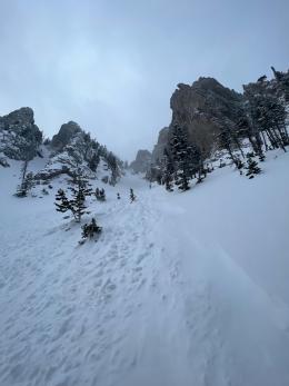
In the mountains near West Yellowstone and Cooke City, a large natural avalanche cycle last weekend following peak storm intensity tipped the snowpack’s hand with avalanches breaking up to 6 feet deep (Alex’s Cooke City Video, avalanche log). Yesterday, I was teaching in the Lionhead area, and participants found a prominent weak layer and unstable conditions near "Ski Hill” (photo). I discussed this weak layer at Lionhead Ridge in my video last week, but with the recent snow, the slab is much thicker.
Yesterday, skiers experienced the snowpack collapsing under their weight at lower elevations just north of Cooke City (observation). Earlier in the week in the Southern Madison Range, skiers near Bacon Rind triggered “whumphs,” and riders near Skyline Ridge in the Taylor Fork noted a weak, faceted snowpack at lower elevations (observation). On Friday in the Taylor Fork, avalanches failing in wind-drifts was my primary concern, but I suggested digging down to look for weak layers before considering steep terrain (video).
Avoid steep wind-loaded slopes where the avalanche danger is CONSIDERABLE. The danger is MODERATE on non-wind-loaded slopes.

In the mountains around Big Sky and Bozeman, strong winds from the west to the southwest are drifting recent snow into slabs where it is possible to trigger dangerous avalanches. Today, the rate of drifting is slowing. As such, wind-loaded slopes may not show signs of instability before avalanching. Look for indicators of ongoing or recent wind loading, such as the stiffening of the snow surface and shooting cracks to identify areas of concern.
Two days ago, a pair of skiers were caught and carried nearly 600 vertical feet in an avalanche that broke 6” deep on Ross Peak in the Bridger Range. One had snow packed into their mouth and under their eyelids when they came to rest on top of the snow (details and photos). In the Northern Gallatin Range, a skier intentionally triggered a test slope that failed 12-18” deep near Lick Creek (photo). At Divide Peak on Monday, I outlined my concerns about wind-loading on slopes and in gullies in my video.
Human-triggered avalanches are possible, and the danger is rated MODERATE.
If you get out, please share avalanche, snowpack or weather observations via our website, email (mtavalanche@gmail.com), phone (406-587-6984), or Instagram (#gnfacobs).

In the last week, the mountains around Island Park received 2 feet of snow. Winds blowing 20-30 mph continue to transport recent snow into thicker slabs where human-triggered avalanches are likely. Avoid steep, wind-loaded slopes, and assess the snowpack for instability related to a slab sitting on a weak layer before considering riding or skiing non-wind-loaded slopes.
Upcoming Avalanche Education and Events
Our education calendar is full of awareness lectures and field courses. Check it out: Events and Education Calendar.
Thursday, December 8, 6 - 7:30 p.m., Free Snow & Avalanche Safety Workshop: Belgrade Community. This workshop will cover the basics of snow and avalanche equipment. Belgrade Community Library. A raffle and pizza will be included!
Monday, December 12, 5-8 p.m. @MAP Brewing, Movie Night.
Tuesday, December 13, 6 p.m., Avalanche Awareness + Beacons at Story Mill Park. Free.
Watch our playlist of YouTube videos to get caught up on our avalanche concerns this season.