Good morning. This is Ian Hoyer with the Gallatin National Forest Avalanche Forecast on Saturday, March 18th at 6:45 a.m. This information is sponsored by Blitz Motorsports and Yamaha and Uphill Pursuits. This forecast does not apply to operating ski areas.
There is no new snow. Winds are 10-15 mph out of the southwest to northwest. Temperatures are in the single digits and teens F. High temperatures today will be in the 20s and 30s F. Skies will be mostly sunny, with increasing clouds near West Yellowstone this afternoon. Light westerly winds will continue today. The next chance for snow is on Monday.

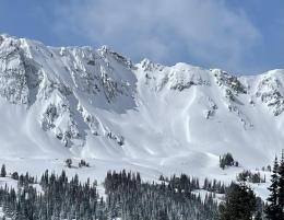
Triggering large avalanches remains likely today in the mountains around West Yellowstone and Cooke City. Avalanches are breaking on weak layers deep in the snowpack including some that were buried all the way back in early January. Yesterday, Doug rode around Lionhead and documented the largest avalanche cycle he’s seen there in his 25 year career (observation, video). There were also huge natural and human triggered slides around Cooke City this past week (video, avalanche log). The snowpack needs more time to adjust to the big load of snow that just got dropped on it by the mid-week storm (2 to 3 feet of snow with 2-2.5” snow water equivalent) before we can begin to trust it.
Sunny skies and fresh powder will make for a beautiful day in the mountains. Steep slopes will look inviting and tempting. Ignore them. Practice patience. There will be a time for riding steep slopes this spring, but today isn’t it. Stick to low angle slopes and even be cautious crossing beneath steep slopes as you could trigger a slide from below.
Springtime concerns should be on the radar today as well. Cornices are primed to break off. Loose wet avalanches are possible as the snow surface gets wet. And roof avalanches are also a real worry around buildings as roofs shed their winter snowpack (close call earlier this week in Island Park, ID).
The avalanche danger is rated CONSIDERABLE.

Around Bozeman and Big Sky, the snowpack is beginning to adjust to the smaller load it got from this last storm (around a foot of new snow). Watch out for areas where the new snow remains reactive and keep the possibility of deep slab avalanches in mind before getting onto steep slopes. It’s been a week and a half since the last deep slab avalanche, but any chance of such a huge slide should make you more cautious (Hyalite Peak slide, Northern Bridgers slide). Be mindful traveling along corniced ridgelines or on the slopes below them as cornices are beginning to release. Expect the snow surface on sunny slopes to get wet and sticky this afternoon, indicating loose wet avalanches have become a concern.
Human triggered avalanches are possible and the avalanche danger is MODERATE.
Please share avalanche, snowpack or weather observations via our website, email (mtavalanche@gmail.com), phone (406-587-6984), or Instagram (#gnfacobs).

Triggering large avalanches remains likely today. The snowpack needs more time to adjust to the big load of snow that just got dropped on it by the mid-week storm before we can begin to trust it. There will be a time for riding steep slopes this spring, but today isn’t it.
See Doug’s video for a rundown on the aftermath of this week’s avalanche warning.
Upcoming Avalanche Education and Events
Our education calendar is full of awareness lectures and field courses. Check it out: Events and Education Calendar.
Sunday, March 26, Avalanche Alliance Sweepstakes! Win a custom 2022 Ford 350 Super-Duty truck or many other items. Proceeds help support avalanche centers. Use code LASTCHANCE to receive 40% more tickets. Winners will be chosen at the Jackson Hole Hill Climb.
Loss in the Outdoors is a support group for those affected by grief and loss related to outdoor pursuits. Check out the link for more information.
A list of all avalanche activity from our forecast area is available HERE.