Snow Observations List
Skied from the summit of both Palace Butte and Maid of the Mist. Based on seeing no signs of snow instability and good terrain selection we had a grand day in the mountains. There was approximately 25 cms of new, dense snow. The SW Montana faceted snow at the ground resides every where we skied and snow above this layer is obviously well bonded.
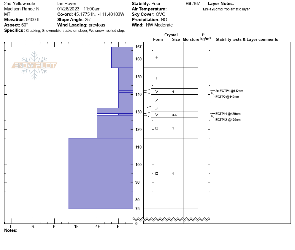
Full Snow Observation ReportWe rode in through 1st, 2nd, and 3rd Yellowmule. There was 5-8” inches of recent snowfall. The only signs of instability we observed was some minor cracking in a drift at the entrance to Second Yellowmule. However, the problem is lurking just under the surface of the snow. Depending on the location, we found one to three layers of surface hoar in the upper 20” of the snowpack. At the top of Second Yellowmule we found repeatable ECTP1s and 2s on a layer of surface hoar 6” below the surface and repeatable ECTP 11s and 12s on a surface hoar layer 18” deep.
The depth and number of weak layers is somewhat irrelevant. The upper snowpack is on edge. Currently, human-triggered avalanches are likely on wind-loaded slopes. We choose to stay clear of avalanche terrain today. And, if tonight’s storm produces as forecast, we will be looking at an avalanche warning by tomorrow morning with natural and human-triggered avalanches likely to very likely. These could fail across wide sections of slopes and be triggered from a distance. We are preparing to stay off steep slope and clear of the runout zones.
Full Snow Observation Report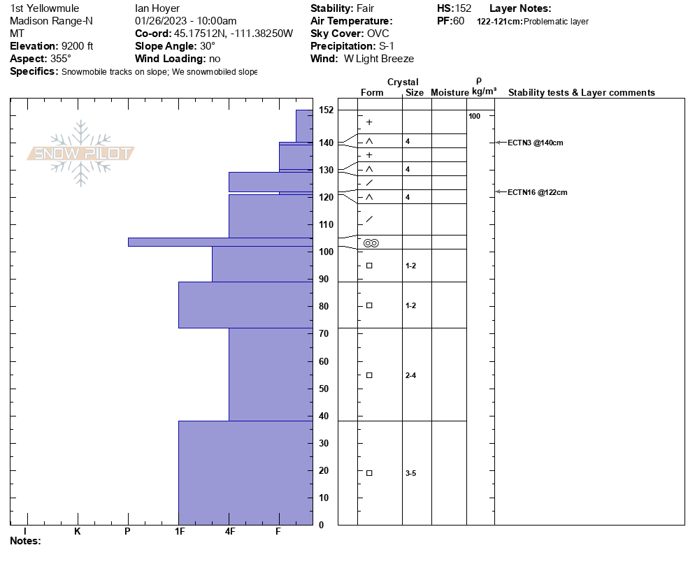

We toured into Beehive Basin for field day 3 of our Pro Avalanche 1 course. We chose to avoid all avalanche terrain today on our ascent and paralleled the private boundary to reach the ridge on the East of Beehive Basin. Each member of our group then completed a full pit profile just below the ridge on W aspects. My pit was dug on a W aspect at 9,012 ft on a 20-degree slope. No active wind loading was observed at the location of my pit. I found snow instabilities approximately 30 cm below the snow surface on a layer of very large-grained surface hoar (CT8 Q2, ECTP2, PST 75/100 End). There were two additional layers of surface hoar buried deeper in the snowpack, although these layers were not reactive and showed signs of rounding and sintering. The basal facets in our pit are rounding and gaining strength and we did not find any instabilities deeper in the snowpack. We would expect to see natural avalanche activity on wind-loaded slopes that have this layer of buried surface hoar if we were to tour into this zone again tomorrow.
Full Snow Observation Report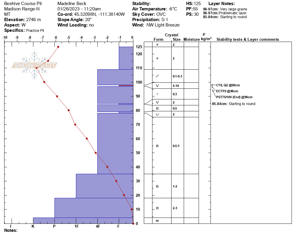
We rode up Denny Creek and over toward Watkins Creek, etc. We observed two recent natural avalanches that broke 1-2 feet deep, presumably on a surface hoar layer. There was a couple of inches of snow on each of these slides, so I would place them between three and five days old. The slides were R1-D1.5 in size - 75-100' wide, 1-2' deep, and 100' vertical fall.
We dug a quick pit with a snow height of 120 cm (4 feet) and found one layer of surface hoar buried 5" deep (ECTP2) and 4 Finger + facets near the ground (ECTP26). We were not concerned about natural avalanches today, but they will be a concern with a few inches of new snow or more on any slope on which the surface hoar is present (assume it is everywhere at Lionhead).
Full Snow Observation Report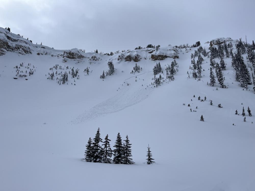
My ski partners and I toured up Flanders creek today and found 9"- 11" of new low density snow. We dug a pit at the base of the SE bowl of Flanders at 9500 ft. The snowpack was 90 cm deep, slightly shallower than what we found on Divide peak last weekend. We found that the new snow was sherring easily in hand pits and we got an ECTP 6 on this interface in our pit. The layers beneath the new snow were faceted junk but not reactive in our tests. The new snow sitting on a firm crust layer was our main concern.
Full Snow Observation ReportWe toured into Beehive for day 2 of our AAI pro 1 avalanche course. We decided to tour up the ridge between “Going Home” and “Tyler’s Run”. We dug three pits as a group on a W aspect at 8700 feet and found generally stable results with no prolongation observed in any of the three pits. We did find a layer of buried surface hoar approximately 37cm below the surface, but evidence that the surface hoar has begun to break down, sinter, and gain strength. We found approximately 10-12in of new snow at elevations above 8,000 ft, which was more than we were expecting. Light snow continued throughout the day with 2-4 inches of accumulation by 2 PM when we returned to our car. We observed light wind transport at the ridge line, but did not find any wind affected snow on the W aspect that we toured up.
Full Snow Observation ReportAn ice climber across the valley observed a large natural avalanche running over Silken Falls ice climb on the east side of the Main Fork. Wind was blowing and moving snow all day. This gully gets wind-loaded and was the site of a fatal avalanche in 2009.
Full Snow Observation ReportMy partner and I were out in a zone south of the bacon rind trailhead today and found some good snow. All of the laps we took today we N NE facing slopes and the snow was supportable and generally stable. We were riding on elevations from 7950 to 7200 all day, and only dug one pit but things were encouraging. I did not do a full profile but we did the usual tests. The total snow height was around 110cm and we got a CT14 Q3 and ECTN12 Q1 both breaking in the now snow around 95cm. Without doing crystal ID and differentiating layers I only got a general hardness scale, from top to bottom it was F-4F-1F+-1F-1F+-4F-G with the section near the ground seeming to be weakening. Overall the snowpack was encouraging but we still kept our riding to lower angle slopes focusing on some pillow lines. No surface hoar was found throughout the day and by the time we left the snow started to fly and the wind stayed light blowing to the northern end of the compass. No recent avy activity was seen on the surrounding slopes. Good snow and good vibes. Thank you all for your hard work, the community appreciates and values what you all do every day!
Full Snow Observation ReportHad some cracking, collapsing of wind drifts up high on the ridge today and few Dry Loose slides running into Wolverine.
Winds were swirling, and coming from the south when I was skiing, but obviously the storm pattern is moving from the north.
Super wind scoured slopes from yesterday not bonding well in other places.
We found bottomless facets on the ski up through the low elevation trees. Once we got close to the ridge we dug a 130 cm pit that was completely unsupportable. It was just layers of facets on facets, ECTX. We then skinned to the top and dug another pit HS100cm, CTX, ECTN25 about 1.5 feet down. There was a supportable slab here and stability was still good. Once this area gets wind and snow I think the danger will bump up quickly. There is so much weak snow around I have a hard time believing it can support much additional weight.
Full Snow Observation Report
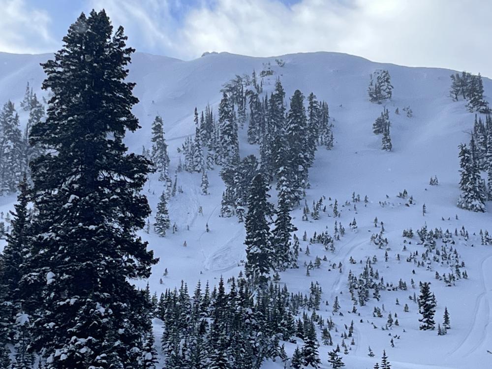
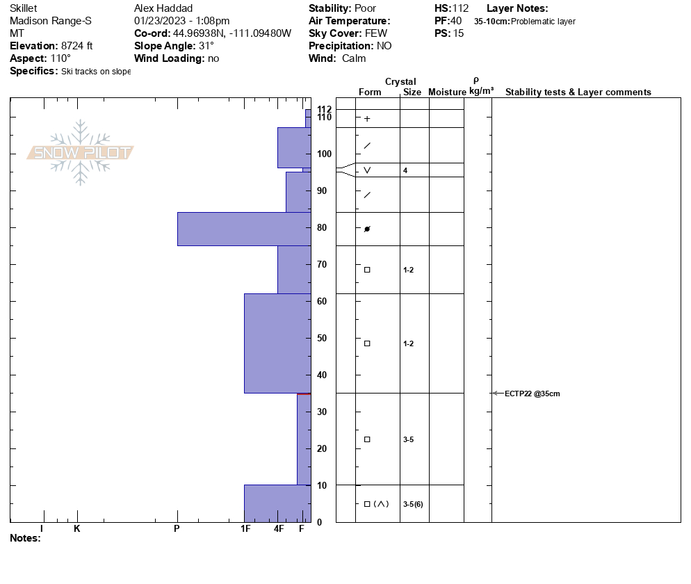
We toured up to the Skillet today. We dug 7 pits on our way up. We found surface hoar buried 6-10” below the surface in all of our pits. This layer failed (ECTN 11 and 12s), but it did not propagate. At this point we were thinking about skiing the Skillet. We dug a pit at the top of the chute at 8,900’. The buried surface hoar was present in this pit, but it did not fail in the ECT. We had an ECTP 22 in facets 2.5’ below the surface of the snow. Because of this result and the terrain traps in the Skillet, we changed our plan and took a more conservative route down. Looking ahead, the buried surface hoar is the primary concern in this area. When we get more snow on top of this layer, instability will increase.
Full Snow Observation Report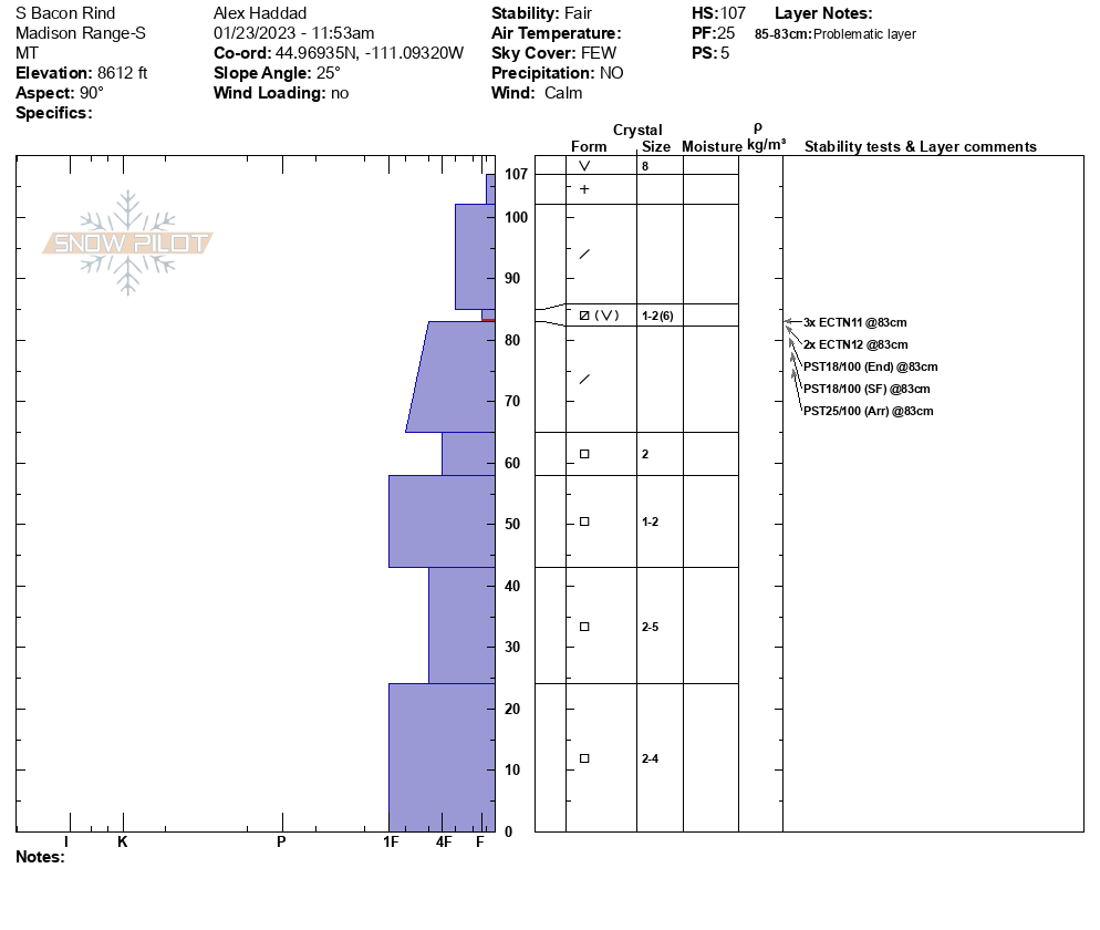

Dug on a sheltered N aspect at 9,000 feet below Alex Lowe Peak. Performed an ECT with results of ECTN 12 at 30cm deep and ECTP 21 near the ground.
We also observed widespread sluffing of the new, low-density snow throughout the day, as well as increasing wind transport in the afternoon.
Full Snow Observation ReportLocation. North of Hebgen lake 1/2mi east of white peak.
Elevation 9200ft/ Aspect S
moderate winds with strong gusts. Isolated wind slabs observed.
HS 140
Compression test
CTH4 RP @115. CTH9 BRK @40
Full Snow Observation Report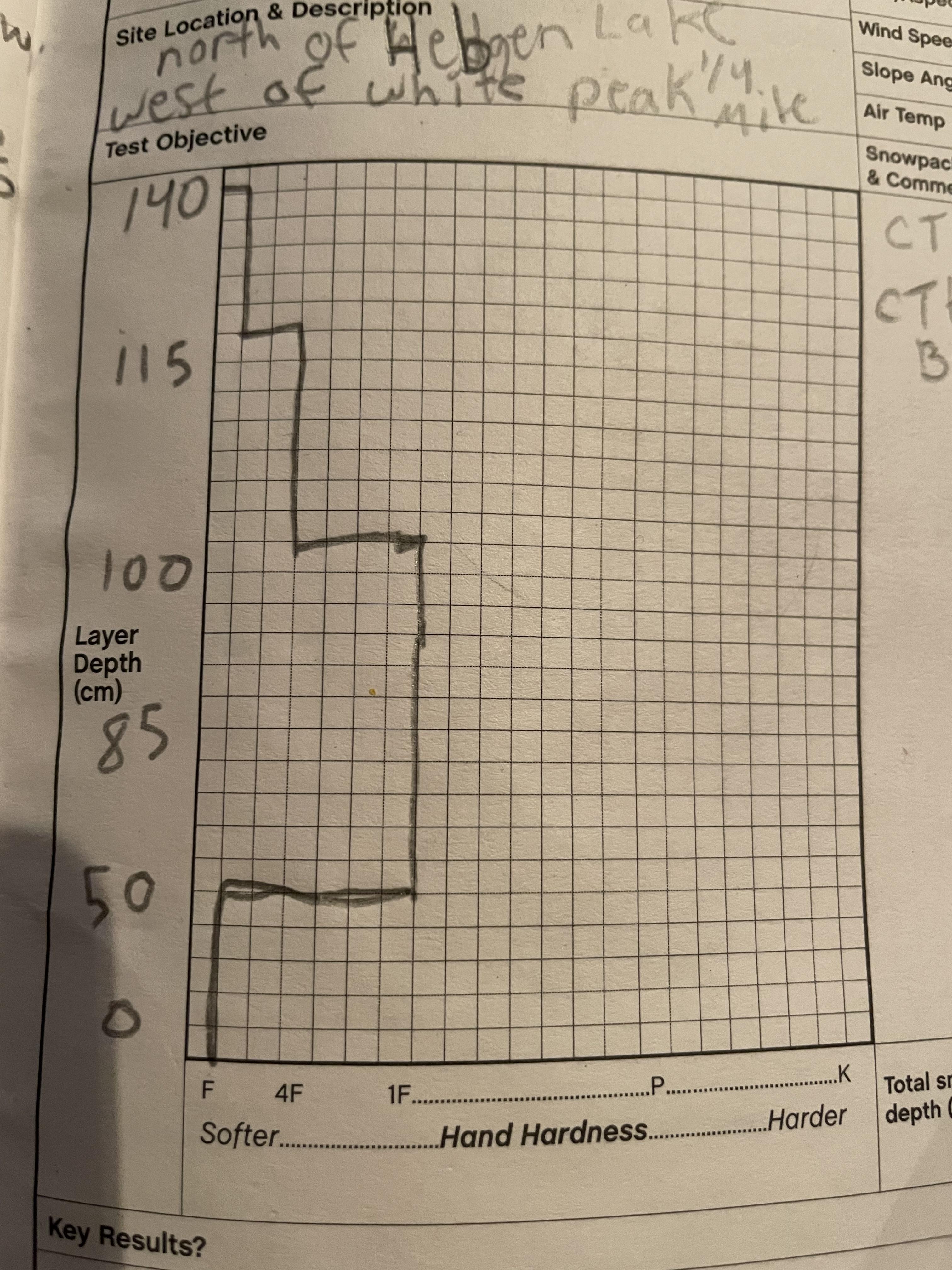
9300 ft North Aspect
165 height of snow, minimal wind effect
ECTP 22 - 35cm down on the buried surface hoar.
First pit over the weekend that produced propagation and obvious signs of instability.
Full Snow Observation Report
Signs of Unstable Snow
Recent Avalanches?
None Observed
Cracking?
None Experienced
Collapsing?
None Experienced
We observed a strong cohesive snowpack on a wind loaded slope NE of Two Top. But we noticed three separate buried SH layers. First 5cm from surface second @ 25cm third @55cm. These buried SH layers tend to be touchy. They are concerning in that the deeper layers rest above and below densely packed wind blown slab.
Three separate layers of Buried SH within the top 100cm of the snow pack. The top layer @5cm from the surface is not worrisome at this time but with added snow in the future it has potential to become a problem layer. The second and third layer @25cm,@55cm,from surface could be human triggered, with the potential of a deadly slab avalanche.
Advanced Information
Weather Summary
Cloud Cover:
Partly Cloudy
Temperature:
17°
Wind:
Light , SW
New/Recent Snowfall:
No resent snow
Upper elevations mostly sunny the past 2 days.Lower elevations experienced AM fog Light winds. We noticed ridge top blowing snow.
Advanced Information
Weather Summary
Cloud Cover:
Partly Cloudy
Temperature:
17°
Wind:
Light , SW
New/Recent Snowfall:
Avalanche Observations
Avalanche Observation Comments:
Observed several natural avalanches on NE ridge at Two Top below cornice in steep wind loaded terrain
Snowpack Observations
NNE aspect 8186ft, 44.62319,-111.24732, HS230,PWL buried SH@ 5cm,25cm,55cm from surface. First test, CTMsc@55 second test CTMsc@25. ECTN27@25
Layer Depth/Date: Jan.22,2023
Weak Layer(s): Jan 5, 2023 (SH)
Comments: Buried SH 5,25, 55, CTMsc@55, CTMsc@25 ECTN 27@ 25
Buried layers of SH. These layer's seem to be very widespread throughout the region. They are worrisome in that they could be human triggerd with deadly potential.
Terrain Use
Our travel Plan to avoid any terrain greater than 30°. There are many options in this area to have a challenging ride without exposing the group to avalanche hazard.
Full Snow Observation Report
Yesterday we toured around Mt Blackmore. We decided to make conservative choices and stay out of avalanche terrain and did not dig a full pit. Next to a meadow we did ski, on a northeast aspect above Blackmore lake, we did a quick ski cut on to a steeper slope. This cut readily released the new snow (~8in at this particular location) and it slid for about 50 feet on a 34 degree slope. This location did not present any signs of significant wind loading. The interface below the snow from the weekend will certainly be something to look out with more snow on the way.
Full Snow Observation Report
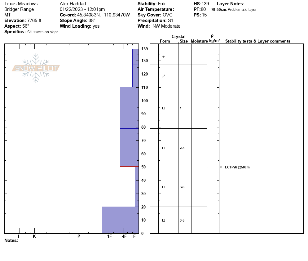
We skied around Wolverine Bowl, the Playground, and Texas Meadows.There were 2-3” of new and wind drifted snow. The winds were gusting 15-20 mph and transporting the new snow. We dug in the Playground at 8,000’ on a N facing aspect, the new snow was moving on the old wind slab (ECTN 1), and the wind slab about 1 foot below the surface did not propagate (ECTN13). The unsupportable wind slab in the playground sent us over to Texas Meadows, and we dug at 7,800’ on the NE aspect. We did not see the wind slab here, and we got an ECTP 26 in the facets near the ground (3’ below the surface). It will take a lot more snow and wind to reactivate this layer. Looking forward to tomorrow the new and wind drifted snow is the biggest concern in the Bridgers--especially in complex avalanche terrain and along the ridgeline.
Full Snow Observation Report

My ski partner and I dug a pit at the base of Divide peak on a SE facing slope at 9,600 ft. We had no failure in our compression test and an ECTX on our column test. The snowpack looked to be completely faceted yet consolidated from the ground to a crust layer just below the new soft snow. There was little evidence of wind loading in the basin and a layer of surface hoar was present on the snow surface. We passed another party who were digging multiple pits on a similar aspect and had the same results we found. We ran into a third party on the summit who dug a pit a few hundred feet from the summit that showed a slightly stiffer slab on the surface but again found stable results. This is still a tricky snowpack and this only shows that conditions were stable on this day at very specific locations. If you venture into Hyalite still do your homework before dropping in!
Full Snow Observation ReportVisible transport on with wind direction shifting from SW to NW in the afternoon. Dug at 7760' asp 85deg slope angle 20 deg on the South side of Bradley's. HS 180 ECTP10 down 25cm. 1F+ hard wind slab over F hardness snow. Slab was not consistent on that aspect at that elevation, we definitely hunted for potential reactivity with many handpits during an avalanche course.
Full Snow Observation Report
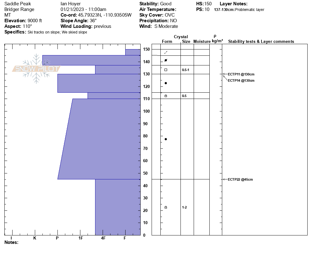
We skied down the "skyline" ridge of Saddle Peak. Recent strong winds drifted snow into small 4" soft slabs near the ridgelines, and there were a variety of new and old hard slabs and scoured surfaces throughout all elevations on the descent. We dug a pit around 9,000' and had an ECTP14 6-10" deep below a very hard slab sitting on sugary facets. We guess this is what the snowboarder triggered avalanche on Wednesday failed on, but that is just a guess. Due to the weak facets some of these hard slabs might be unstable for a few more days. Snow depth was 150-210cm where we dug. There is weak snow near the bottom of the snowpack that we need to remember for when there is heavier loading from snow and wind, but it seems unlikely it will cause an avalanche right now with little recent snowfall.
Full Snow Observation Report