Good morning. This is Alex Marienthal with the Gallatin National Forest Avalanche Forecast on Monday, January 30th at 7:15 a.m. Today’s forecast is sponsored by Alpine Orthopedics & Sports Medicine, Cooke City Motorsports, and Chad Bunting-Financial Advisor-Edward Jones. This forecast does not apply to operating ski areas.
This morning there is no new snow. Temperatures are 10-20 degrees below zero F. Wind is out of the northwest to west at 10-25 mph with gusts of 20-35 mph. Today, under mostly sunny skies, temperatures will reach single digits above zero F with west-northwest wind at 15-25 mph. The next chance for snow is tomorrow through Wednesday.
Wind out of the northwest-west increased overnight and is drifting snow into thicker slabs that make human-triggered avalanches likely today. Fresh wind slabs will be easy to trigger, and could cause avalanches to break deeper and wider on weak layers buried below the 1-4 feet of new snow that fell a couple days ago.
Since snowfall ended on Saturday morning the snowpack had a break to adjust to the weight of the storm (1-4” of snow water equivalent), and on non-wind loaded slopes the likelihood of avalanches has decreased. However, buried weak layers make it possible to trigger large avalanches for many days, on steep slopes or from lower angle terrain below steep slopes.
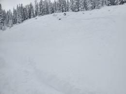
Yesterday, Dave rode near Cooke City and found layers of feathery, weak surface hoar buried 1-3 feet deep, and he saw recent avalanches that broke under the 1-2 feet of new snow (video, photos). On Saturday Doug and I looked at an avalanche in Taylor Fork that broke 1-2.5’ deep on similar weak layers (video, details and photos). Last week we saw clear evidence of these buried weak layers layers near West Yellowstone (natural avalanche at Lionhead) and Big Sky (unstable snowpack tests on Buck Ridge video). And, in the Bridger Range and Hyalite we documented weak snow on many slopes prior to the recent heavy snowfall (Bridgers video, Mt Ellis video).
Over the last three days, people reported many large natural and human-triggered avalanches. You can browse the details on our avalanche activity page. These show what is possible today, and are a reminder to remain extra cautious of slopes steeper than 30 degrees and lower angle terrain below steep slopes.
Today, avoid steep slopes that have fresh drifts. Watch for large plumes of snow blowing off ridgelines or cracking across the snow surface around your skis as indicators of where fresh drifts exist. On non-wind loaded slopes, carefully assess the stability of the recent new snow, and dig to look for buried weak layers. Avalanche danger is CONSIDERABLE on wind-loaded slopes and MODERATE on all other slopes.
Please share avalanche, snowpack or weather observations via our website, email (mtavalanche@gmail.com), phone (406-587-6984), or Instagram (#gnfacobs).

Wind increased overnight and is drifting snow into thicker slabs that make human-triggered avalanches likely today. Fresh wind slabs will be easy to trigger, and could cause avalanches to break deeper and wider on weak layers buried below the 1-4 feet of snow that fell a couple days ago. On non-wind loaded slopes the likelihood has decreased, but it remains possible to trigger a large avalanche. Today, avoid slopes that have fresh drifts. On non-wind loaded slopes, carefully assess the stability of the recent new snow, and dig to look for buried weak layers.
KING AND QUEEN OF THE RIDGE, FEBRUARY 4TH
Do you like to hike? Do you like to ski? Then the King & Queen of the Ridge is for you. Hike, ski and raise money for the Friends of the Avalanche Center in their 2nd biggest fundraiser of the year. Join the effort to promote and support avalanche safety and awareness! Fundraising prizes for the top 5 individuals who raise over $500. No racing is necessary to compete for the fundraising prizes. Info is HERE. Race participants for the February 4th event must register separately with Bridger Bowl HERE.
Upcoming Avalanche Education and Events
Our education calendar is full of awareness lectures and field courses. Check it out: Events and Education Calendar.
February 4, 9 a.m.-3 p.m., LIVINGSTON Avalanche Fundamentals. Information and course registration are HERE.
February 5, 10 a.m.-2p.m. Companion Rescue Clinic Field Day in the Bozeman area. Required Online Classroom Session at 6 p.m. on Feb 3. Information and course registration are HERE.
February 9, FREE Avalanche Awareness at REI Bozeman. More details to come.
February 11, 10 a.m.-2p.m. Companion Rescue Clinic Field Day in the Bozeman area. Required Online Classroom Session at 6 p.m. on Feb 10. Information and course registration are HERE.
Every Saturday, 10 a.m. - 2:00 p.m. Avalanche Rescue Training, drop in for any amount of time. Round Lake Warming Hut, Cooke City. Free.
Loss in the Outdoors, is a support group for those who have been affected by grief and loss related to outdoor pursuits. Check out the link for more information.
Check out the weather and avalanche log for a rundown of recent weather and avalanche conditions.