Good morning. This is Dave Zinn with the Gallatin National Forest Avalanche Forecast on Thursday, April 11th, at 7:00 a.m. Today’s forecast is sponsored by Alpine Yamaha in Livingston and the Yellowstone Club Community Foundation. This forecast does not apply to operating ski areas.
Mountain temperatures are in the 20s to low 30s F this morning, with 5-15 mph wind from the west to southwest, and there is no new snow. Today, temperatures will be in the 40s to low 50s F under mostly sunny skies. Winds will be 5-15 mph from the west to southwest.

All Regions
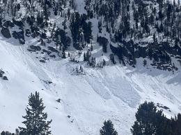
Yesterday, lingering cloud cover in the morning kept wet snow avalanches mostly at bay for an extra day. Today will be 5-10 degrees warmer, and direct sun will bake slopes, increasing the danger of wet snow avalanches. These will generally slide as loose snow that starts at a point and fan out as they entrain more snow. While small, these slides have the consistency of wet concrete and can quickly sweep a skier or rider off their feet, pushing them toward terrain trap obstacles such as trees, cliffs and gullies. Less likely are larger wet slab avalanches that can break widely across slopes like this avalanche on the Fin in Cooke City one week ago (photo). Recognize increasing danger as the upper 6 inches of the snowpack becomes wet and slushy or you observe rollerballs and small wet snow avalanches. Move to cooler aspects or return to the trailhead before conditions deteriorate.
At upper elevations and cooler aspects where the snow remains powdery, dry slab avalanches are the primary concern, especially on slopes loaded by wind-drifted snow. While these are becoming less likely as we move away from the last snowstorm (avalanche activity log, Ramp video, Throne video), dig down through the recent snow, test for instability above the thick melt-freeze crust, and watch for signs of instability, such as cracking at the snowpack surface. Retreat to lower-angle slopes and non-wind-loaded terrain if you observe signs of instability.
Skiers south of Cooke City dug a snowpit to the ground in a shallower area and used an extended column test to investigate the weak faceted snow that continues to make up the foundation of our snowpack. The group was surprised when the test propagated, indicating continued basal instability (observation). While avalanches failing near the base of the snowpack have become much less likely, the potential remains, especially on slopes that remained cooler during this winter’s warm-ups.
Human-triggered, dry snow avalanches are possible, and the danger is MODERATE. Wet snow avalanches will become likely as the day warms, and the danger will rise to CONSIDERABLE.
Our last daily forecast of the season is Sunday, April 14.
If you get out please submit an observation. It does not need to be technical. Did you see any avalanches? How much snow is on the ground? Was the wind moving snow? Simple observations are incredibly valuable. You can also contact us by email (mtavalanche@gmail.com), phone (406-587-6984), or Instagram (#gnfacobs).
Upcoming Avalanche Education and Events
Hyalite Road Closure: Hyalite road is closed to ALL MOTORIZED VEHICLES until the morning of May 16. This is a regular annual road closure to reduce road damage during the spring thaw. Bicycle and foot traffic are allowed. Contact the Bozeman FS Ranger District for more info.
Events and Education Calendar.
Loss in the Outdoors is a support group for those affected by loss and grief related to outdoor pursuits. Check out the link for more information.
Lorea Zabaleta wrote a great article in the Bozeman Daily Chronicle highlighting the work of the GNFAC. You can read it here.