Snow Observations List
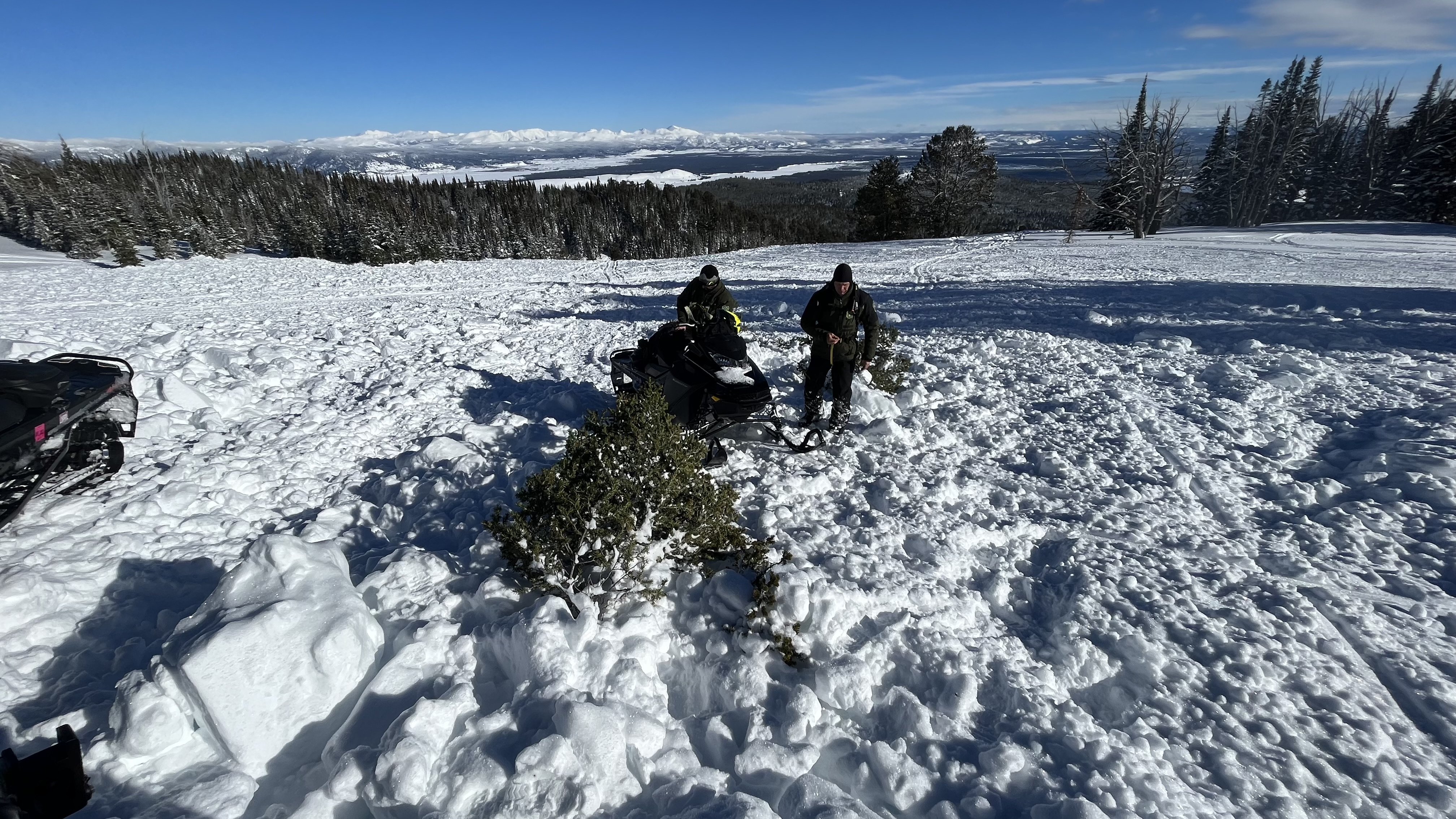
We rode back to the recommended wilderness boundary through Denny Creek, Watkins Creek, etc. We saw the avalanche triggered by a ground of riders around the corner from Airplane Bowl. It was 150’ wide x 4-5’ deep and 150-200’ vertical. The debris was piled 5-6’ deep, certainly deep enough to bury or injury a rider or skier. This was a close call.
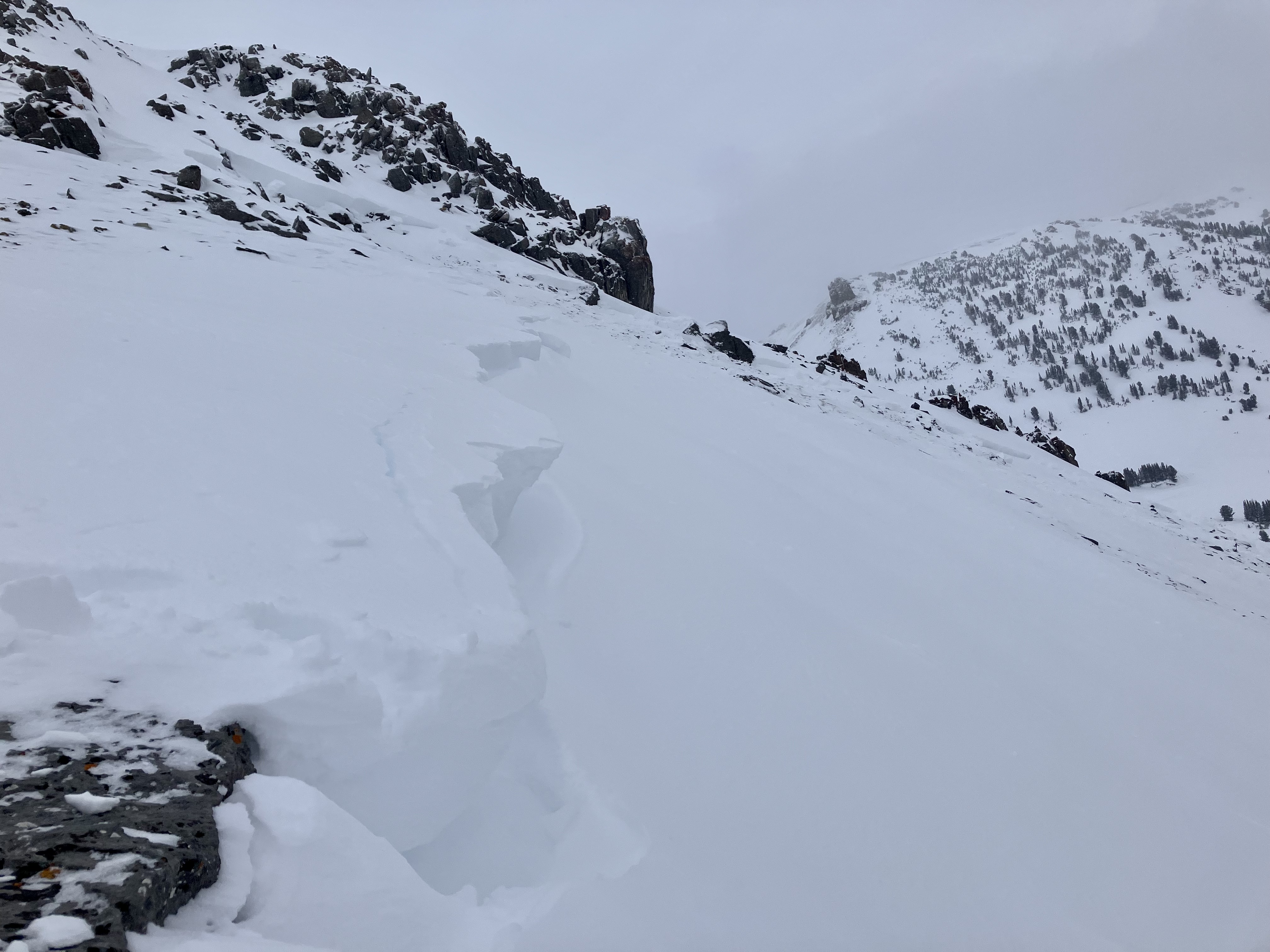
We observed several recent storm and wind slab avalanches from Lionhead Ridge but not other deep slab avalanches. The snowpack structure is similar to what we have seen in the past rides to the area, a 3” thick layer of facets 1-2’ deep and facets buried near the base of the snowpack. Avalanches are becoming less likely without new snow, but the structure will keep the danger heightened for a while.
Looking forward, there was surface hoar covering most slopes, and it is supposed to snow lightly through the week. We will be watching this for a possible new layer of concern.
Full Snow Observation Report

Drifting snow on ridges at 7,850 ft E aspect.
Obvious Rime on trees 7,850 ft.
Distinct PWL cohesive with previous obs.
Full Snow Observation Report
Went up to Flanders today, dug a pit at approximately 9800ft on an east aspect. Snow depth was 154cm, with about 20cm of weak snow at the ground. We also found a weak layer at 112cm, which had a planar fracture during our shovel shear. Had an ECTx result, and when prying the column it pulled out as a cohesive block all the way to the ground. There was also quite a bit of surface hoar growth from about 7200ft to just below the summit.
Full Snow Observation Report1-2cm surface hoar encountered near 8000’on NW through NE aspects in the Mill Creek region of the Absarokas outside Livingston.
Full Snow Observation Report
At about 10 AM I was belaying my partner on the first pitch of Bobo Like in the Flanders drainage of Hyalite Canyon. We heard a low rumble and a couple seconds later we were engulfed in snow that poured out of the the pitch 2 gully, and seemed to keep coming for about 5 seconds. My partner, who was on lead, was lucky enough to be at the base of the vertical ice of p1, so the snow mostly went over his head. I was off to the side and close to rock at the base and was engulfed in loose snow, but not buried or injured. We continued up afterwards. When I was at the top of the second pitch, belaying my partner up, another small loose snow avalanche came down as river of snow, passing me as I hugged the anchor, and washed over my partner while he was on the pitch. We were fortunate to have both been in positions to handle these avalanches without incident or injury. In retrospect, the clear day and blasting morning sun likely loosened the snow above the gully and funneled it all down onto us. After the first avalanche, the sun must have kept moving onto new slopes above, releasing more snow. Even with a moderate danger level in the avalanche report for the day, with natural avalanches unlikely, we happened to find ourselves in a very specific scenario, with morning sun and a dangerous terrain feature, that still put us at risk. Hopefully we will use this experience to improve our assessment of risk, terrain, and evolving conditions in the future.
Full Snow Observation Report
Skiers north of Bridger on 1/1/23 reported: "... an unexpected ECTP turned us around. We stopped on dug on a north-facing slope just past the entrance to Wolverine. We got an ECTP 11 about a foot under the surface on what was either a thin layer of facets or just a density change under a hard wind slab. I didn't have a lens so it was hard to tell. Either way, it made us change plans and head back... We also saw a good-sized natural on Saddle between the top and the football field. It appeared to only involve fresh wind drifted snow."
Full Snow Observation ReportGreat riding and beautiful views all day. We did not observe any avalanche activity, but we did not cover much of the range's western portion. We did get some long views from the top of Sawtelle.
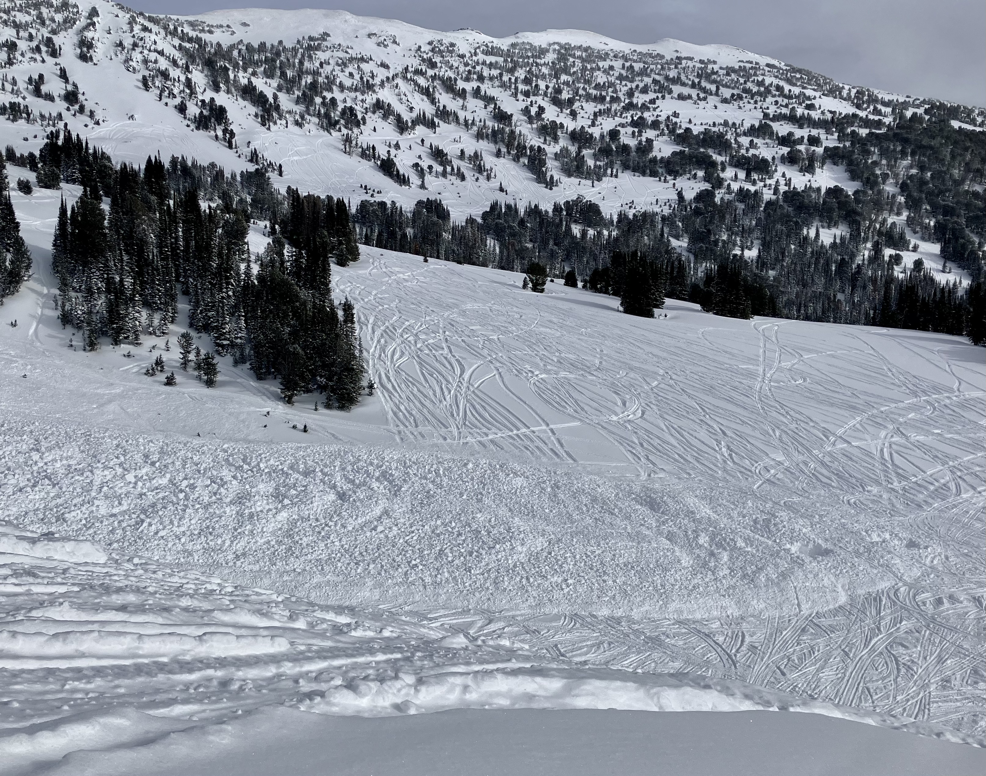
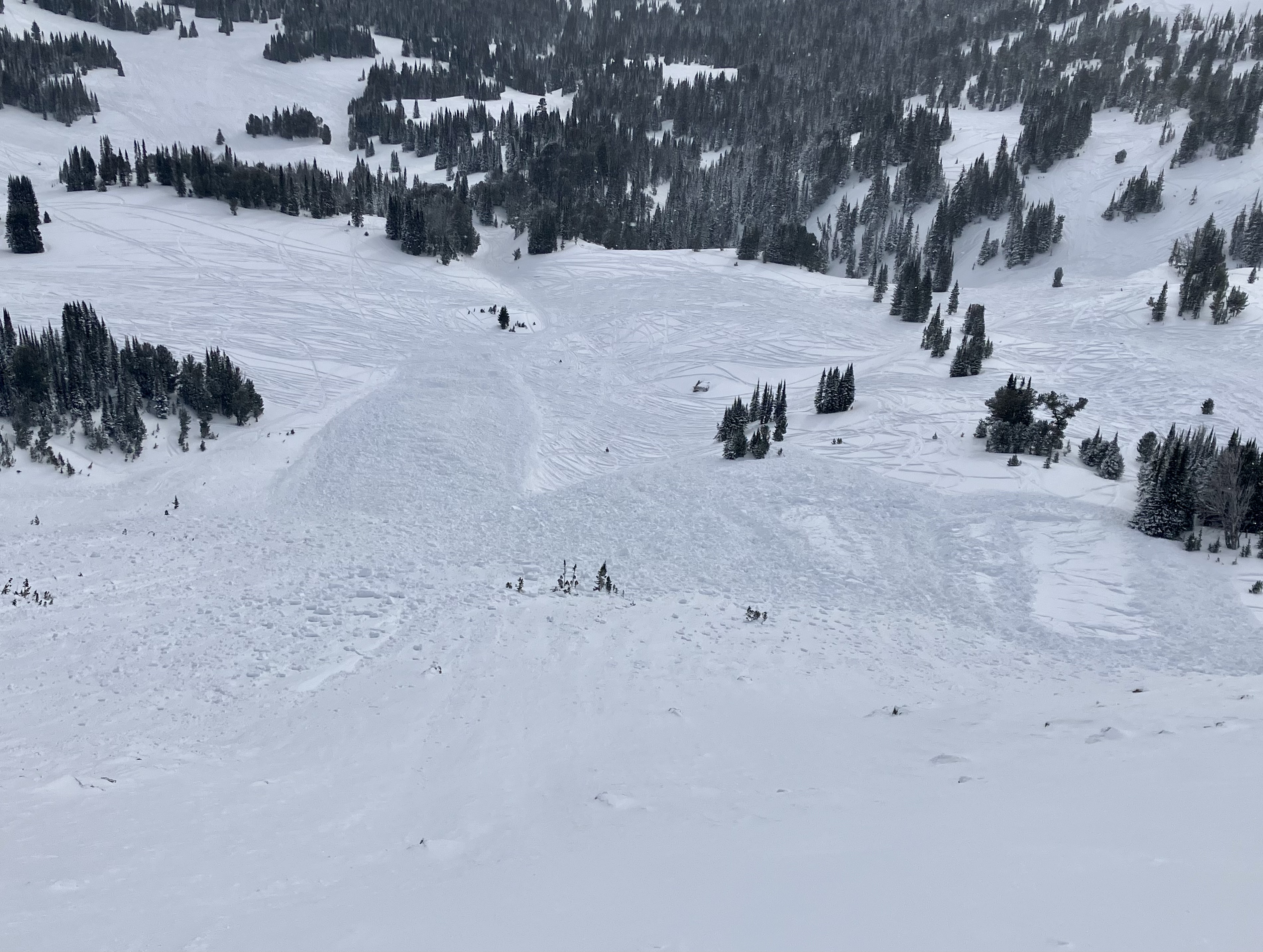
In our snowpits, the structure generally looked similar to what we have seen in the Lionhead area. There is a 2-3” thick layer of facets buried 18-24” deep and a layer of facets near the bottom of the snowpack. In the deeper of our two pit locations, these layers are 1F hardness and I guess they are strengthening. However, we did have propagating results in both pits on the layer buried 18-24” deep (ECTP26 and ECTP28) and near the bottom of the snowpack in our shallower pit above East Hotel Creek (ECTP20). Human-triggered avalanches are possible on either of these layers, but we didn’t see evidence (avalanches) that they are hair-trigger or a widespread issue at the moment. Conditions will become dangerous during the next loading event.
Full Snow Observation Report


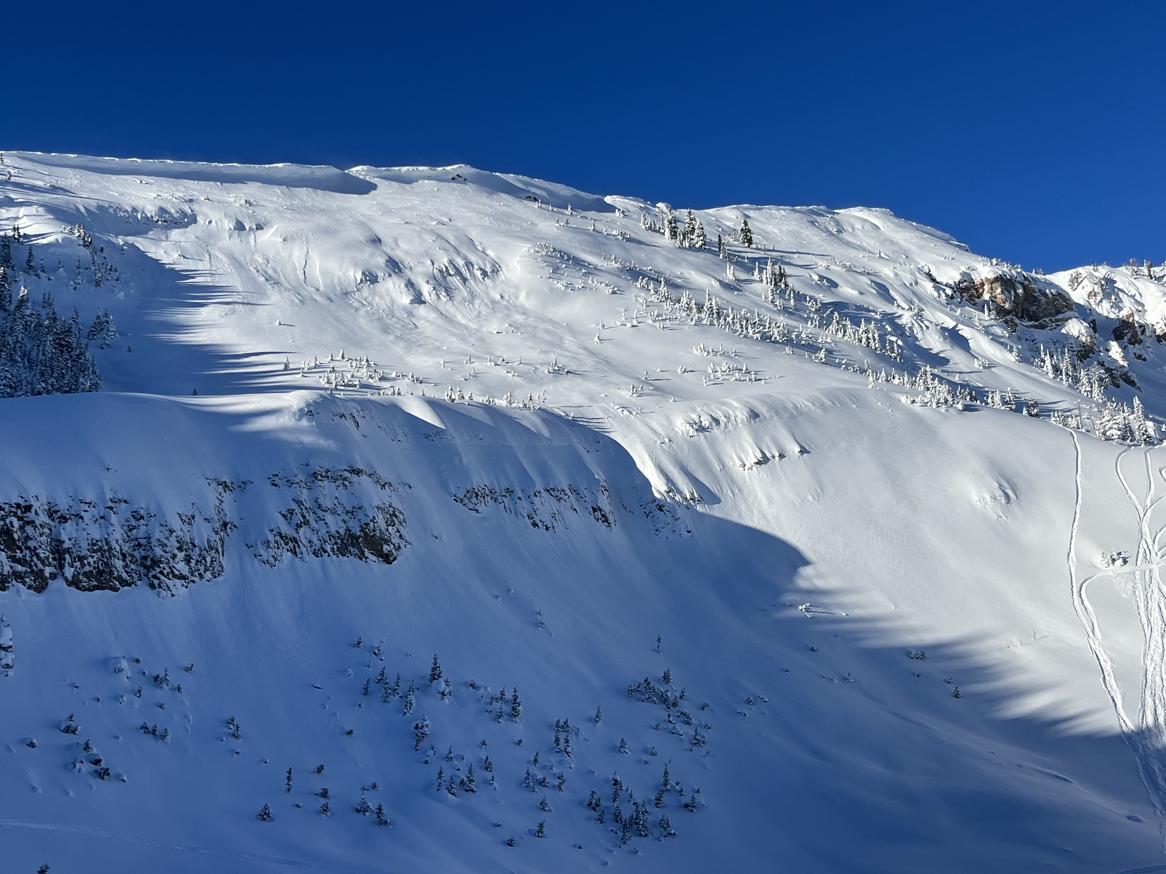
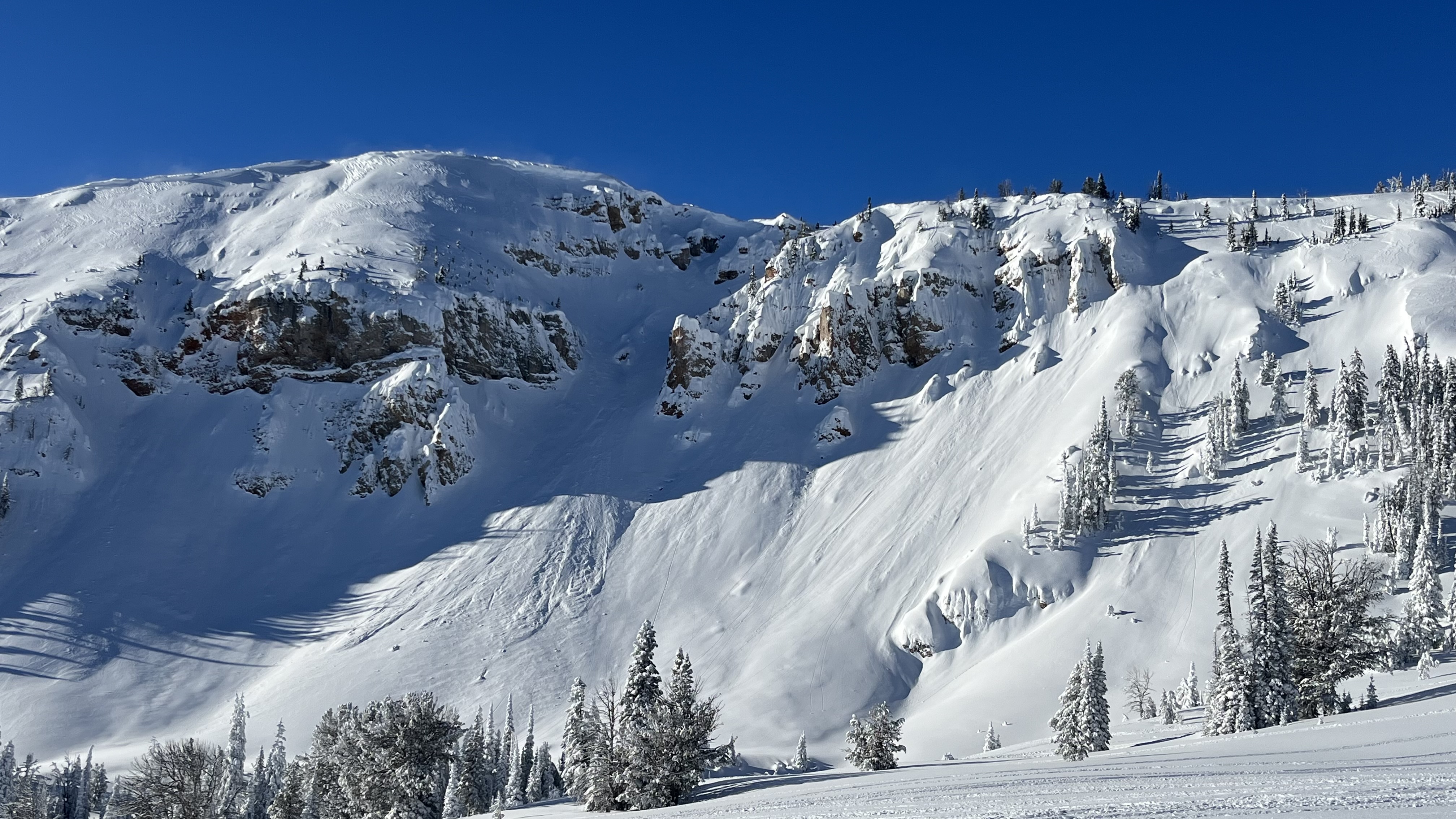
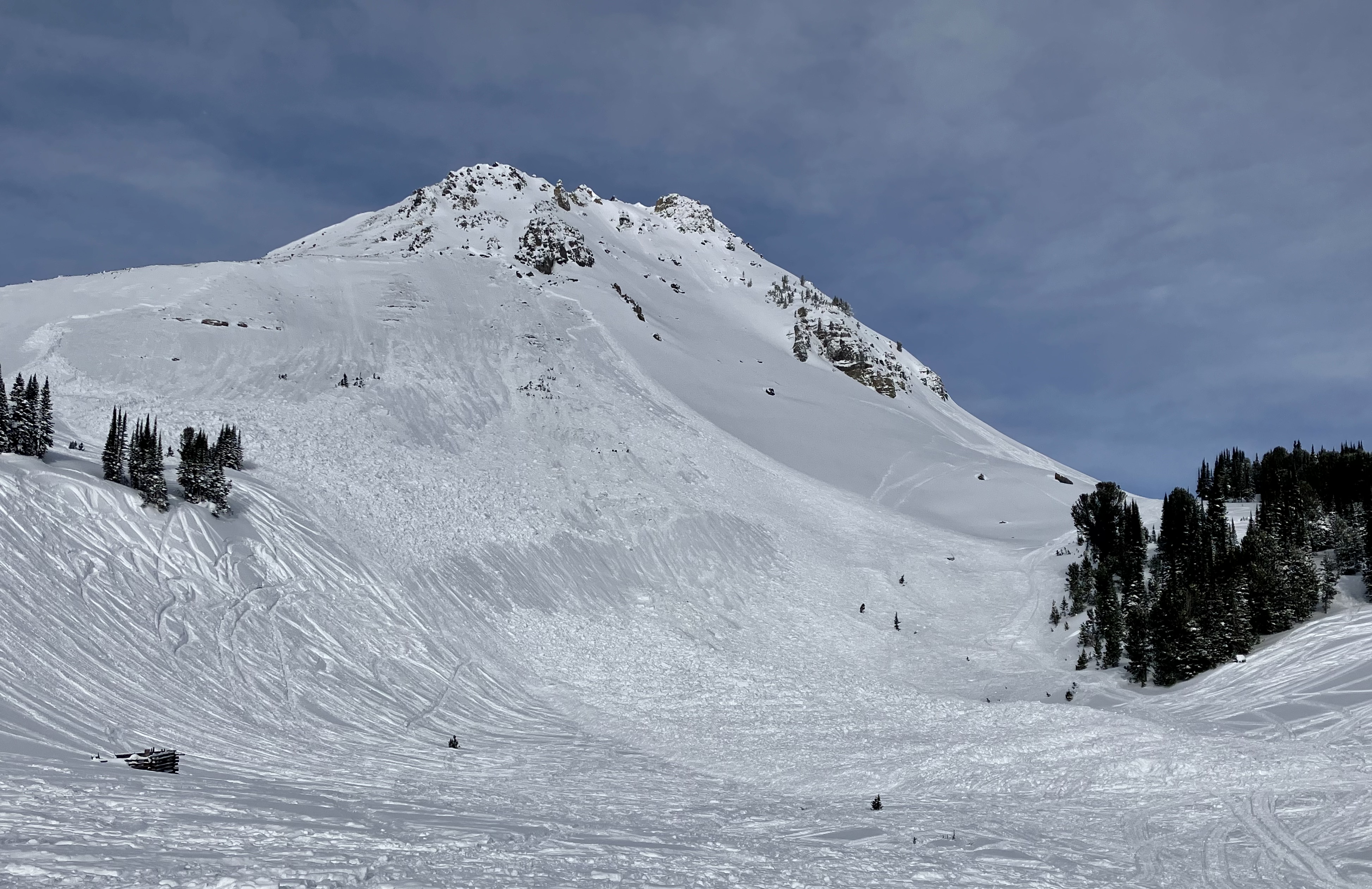
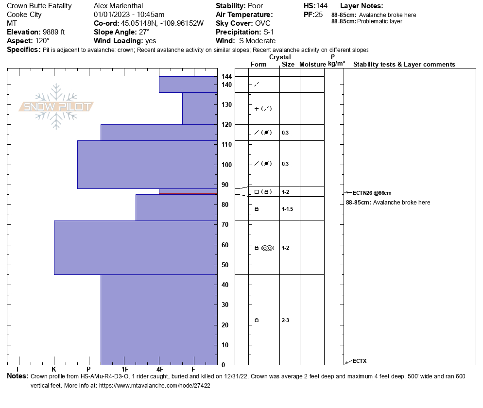
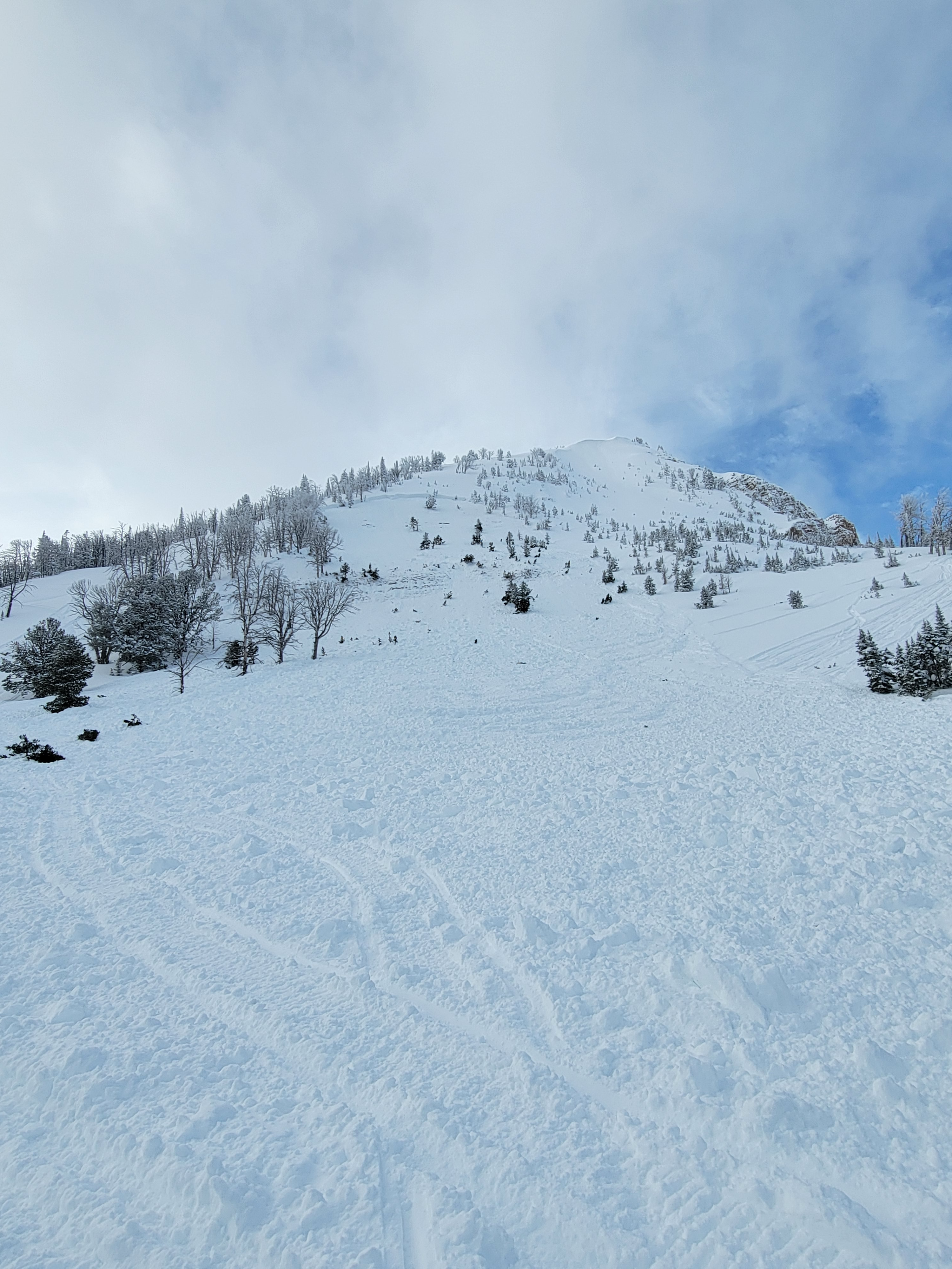
We looked at the avalanche that killed a snowmobiler yesterday (12/31/22) on Crown Butte near Cooke City. It occurred on a southeast facing slope at 9,800 feet elevation. At the crown the avalanche was 1.5-2 feet deep on average, and up to 4 feet at the deepest. It broke 500 feet wide and ran 600 vertical feet. It was a hard slab avalanche that broke on weak, sugary snow, and was large enough to break trees or destroy a car. Our deepest condolences go out to the family and friends of the victim, and those involved with the rescue and recovery.
Full Snow Observation Report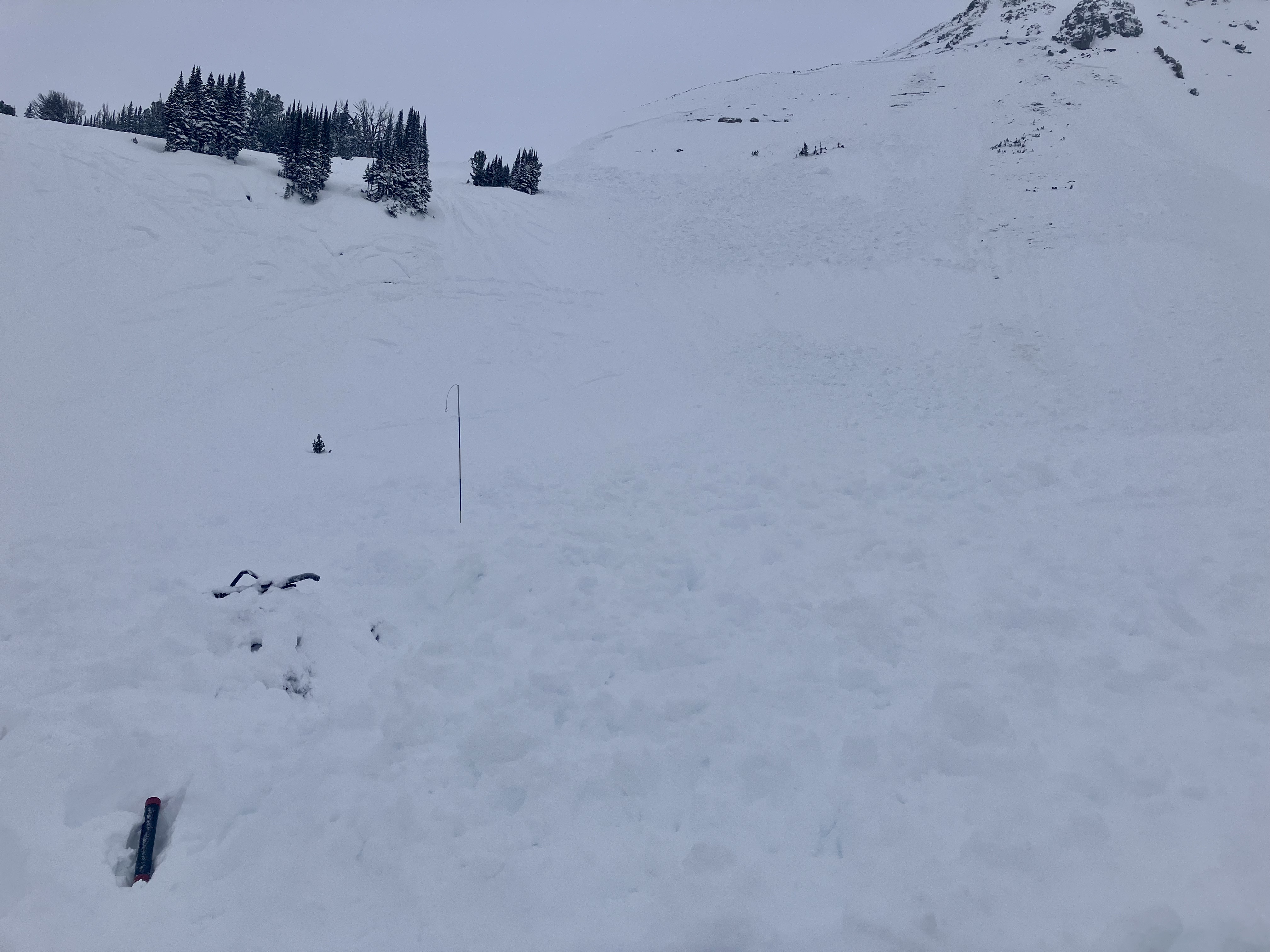


Snowmobile triggered avalanche west face of Sheep
Full Snow Observation Report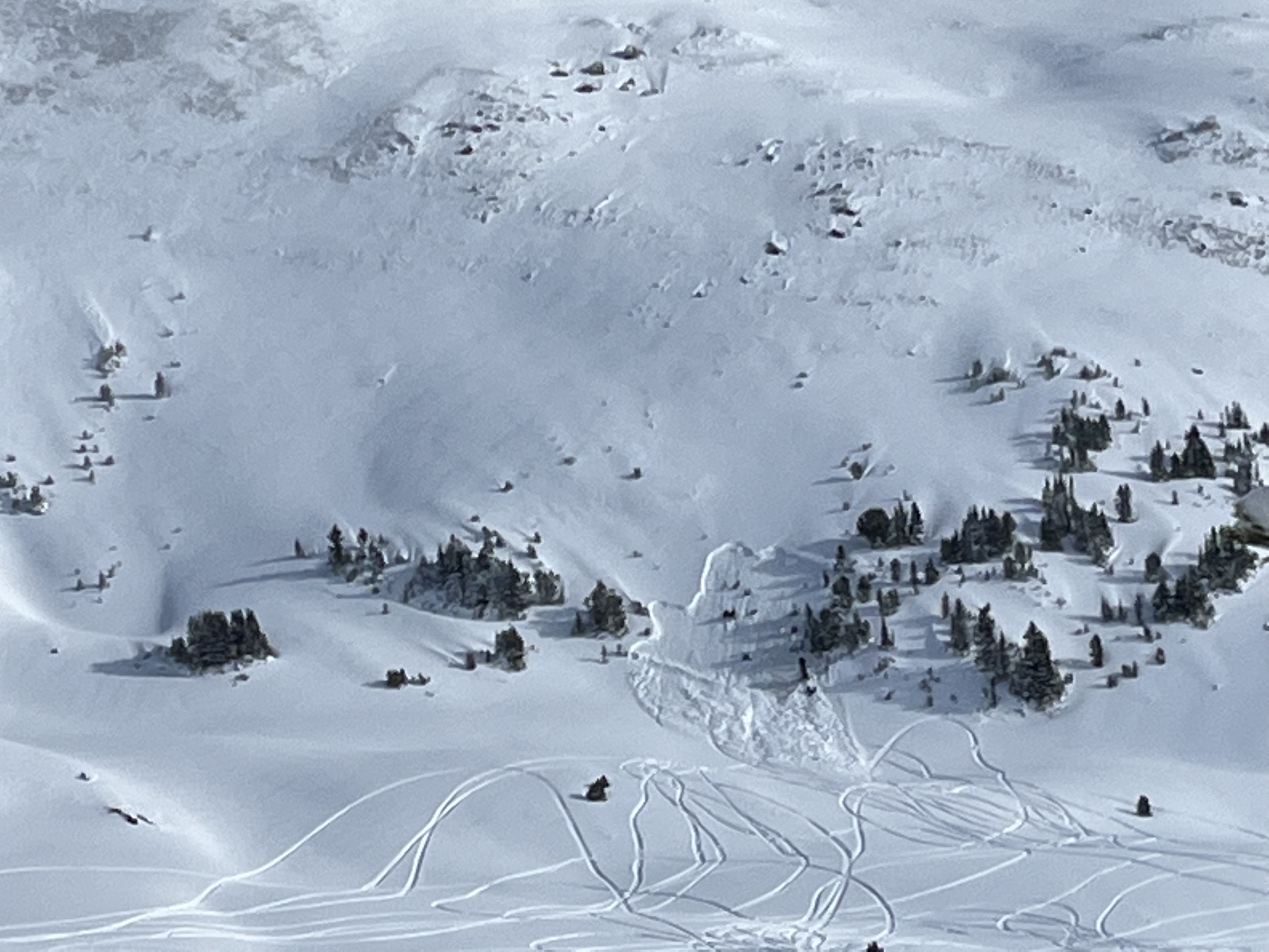

Today my partner Henry and I toured around the fields between Barronette and Warm Creek pass. Overnight snow was approximately 2” with storm total about 12”. We dug a pit on an E aspect at 8,200’, HS 152cm, ECTX, CT23 (RP) 50cm down on a density change. Aside from the density change that produces CT result, and 15cm of basal facets, the snow pack was right side up with no signs of instability or natural avalanche activity throughout the day. Ski quality was excellent.
Full Snow Observation ReportSurface hoar south to south east aspects, potentially more aspects, will confirm later this afternoon.
Full Snow Observation Report
On December 31, 2022 a snowmobiler was killed in a very large avalanche north of Cooke City, MT. The avalanche occurred near Daisy Pass on Crown Butte on a southeast facing slope at 9,800’. Two brothers (age 17 and 21) from Washington were snowmobiling uphill on adjacent slopes. The older brother was climbing a steeper slope and triggered the avalanche 100-200’ below the top. He was carried 600 vertical feet and buried 5 feet deep. The buried rider was wearing an airbag pack that was not deployed. Both riders had shovels and probes. They were not wearing avalanche beacons. A nearby group of riders rode up to the slide within minutes after it happened, saw a buried snowmobile and began to search for the rider. One rider from that group went into Cooke City to alert Search and Rescue. The buried rider was located with a probe line an hour after the avalanche happened. He was unable to be revived with CPR and AED at the site. Our deepest condolences go out to the family, friends, and those involved.
The avalanche appeared to be 2-4' deep, 500' wide, 600' vertical, and broke on weak snow near the bottom of the snowpack. AMu-HS-R3/4-D3-O
Full Snow Observation Report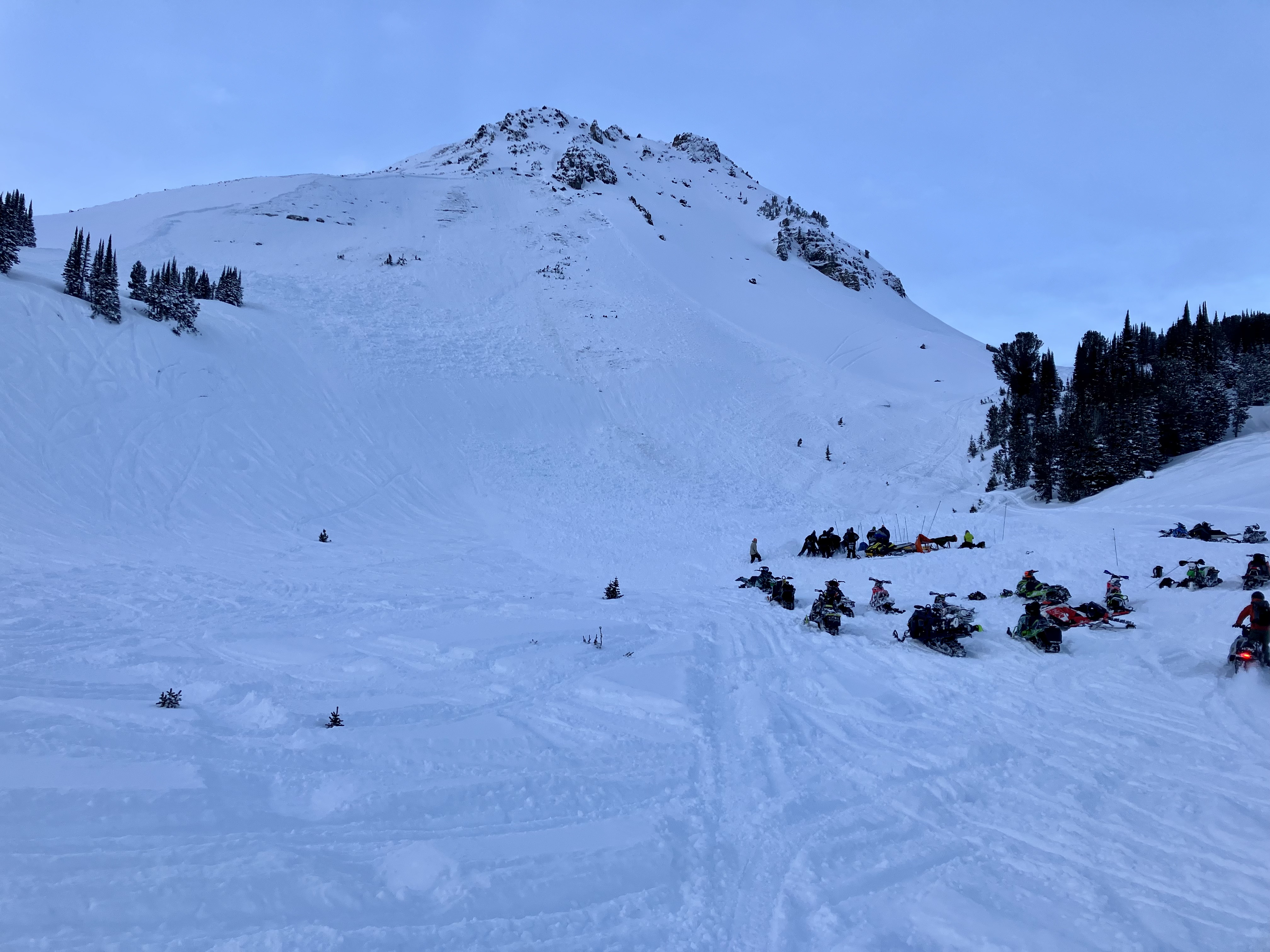


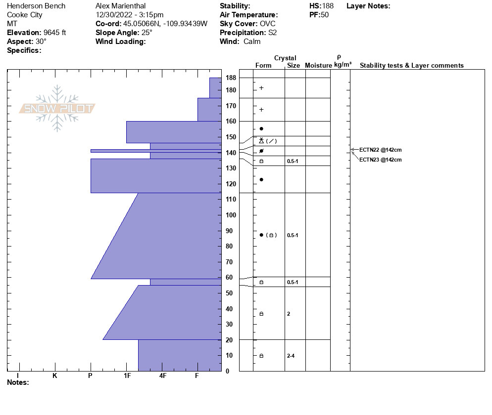
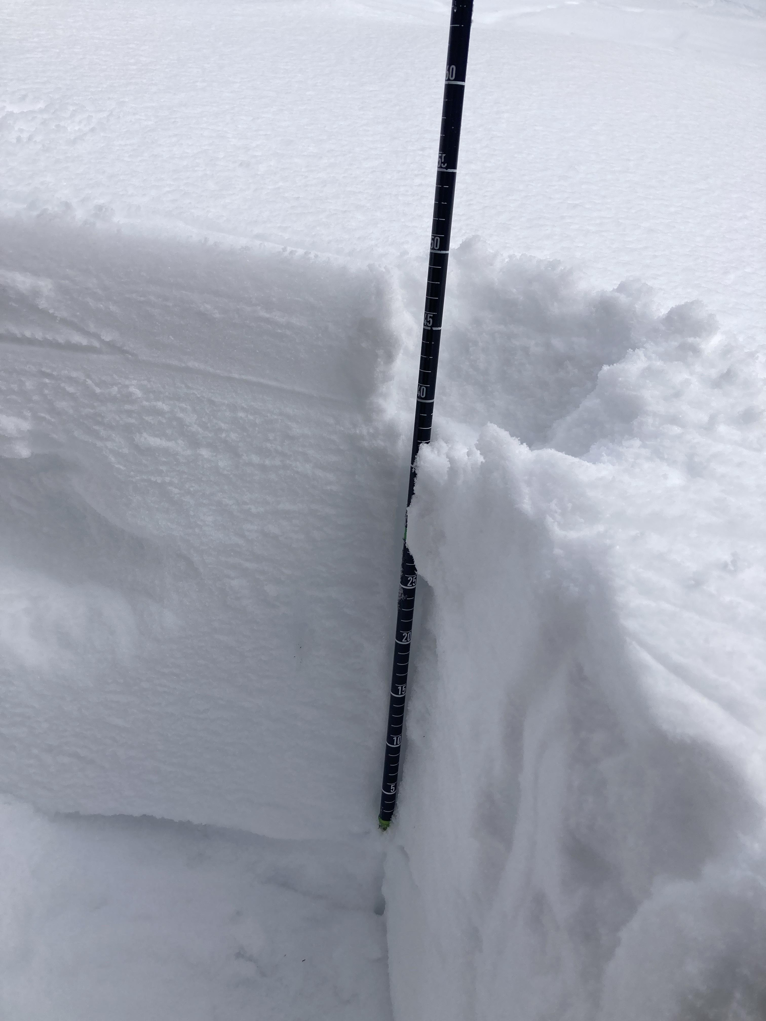
Yesterday afternoon (12/30) we rode to Henderson Bench and dug a pit at 9,600' on a NE facing slope. HS was 188cm and we had ECTN22 and ECTN23 at 146 cm above the ground. New snow from the last week was over a foot deep and it was snowing steadily, an inch an hour at times while we were out. Snowfall tapered off in the evening, then this morning dropped 4" in town and more in the mountains.
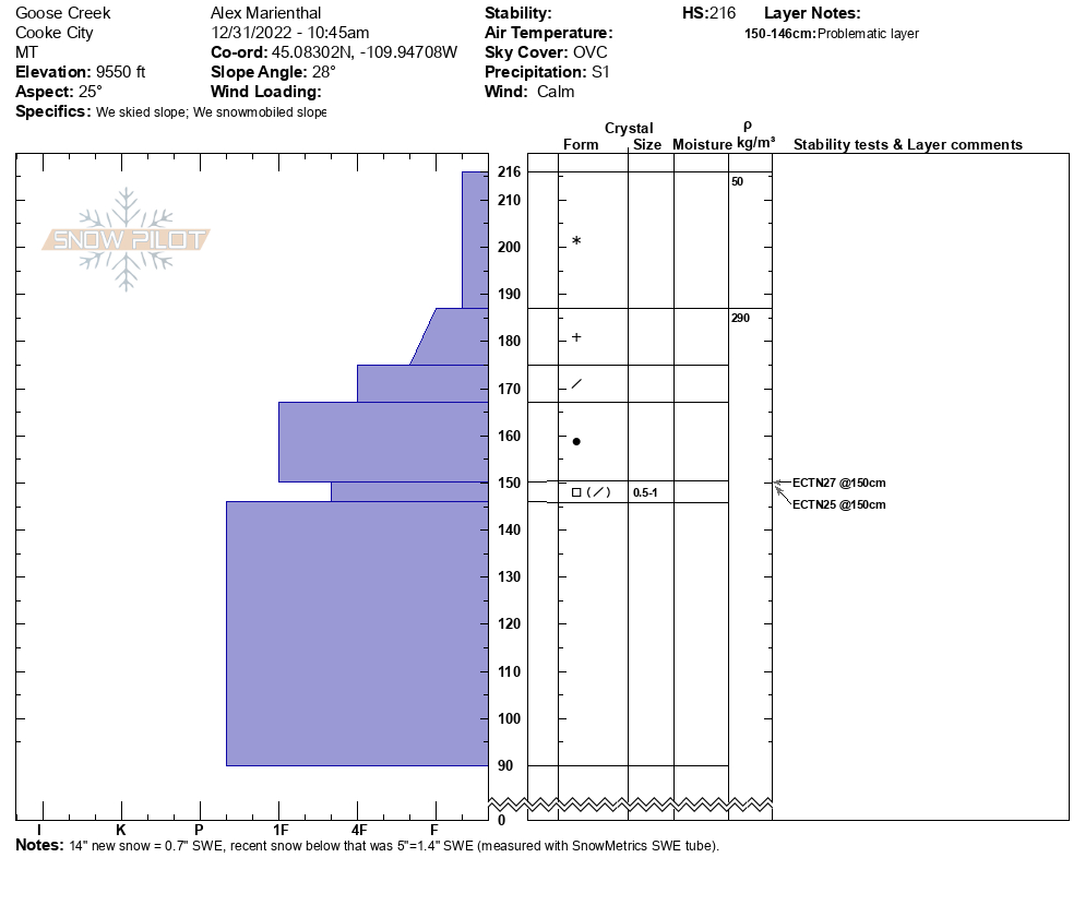
Today we were rode north of Cooke City. We rode over Lulu Pass and dug a pit at Goose Creek at 9,500' elevation on a NE facing slope. HS was 216 cm with 40cm of new snow from the last couple days. The top 14" of the new snow weighed 0.7" snow water equivalent. We got ECTN 25 and ECTN 27 at 150cm above ground on facets sized 0.5-1mm.
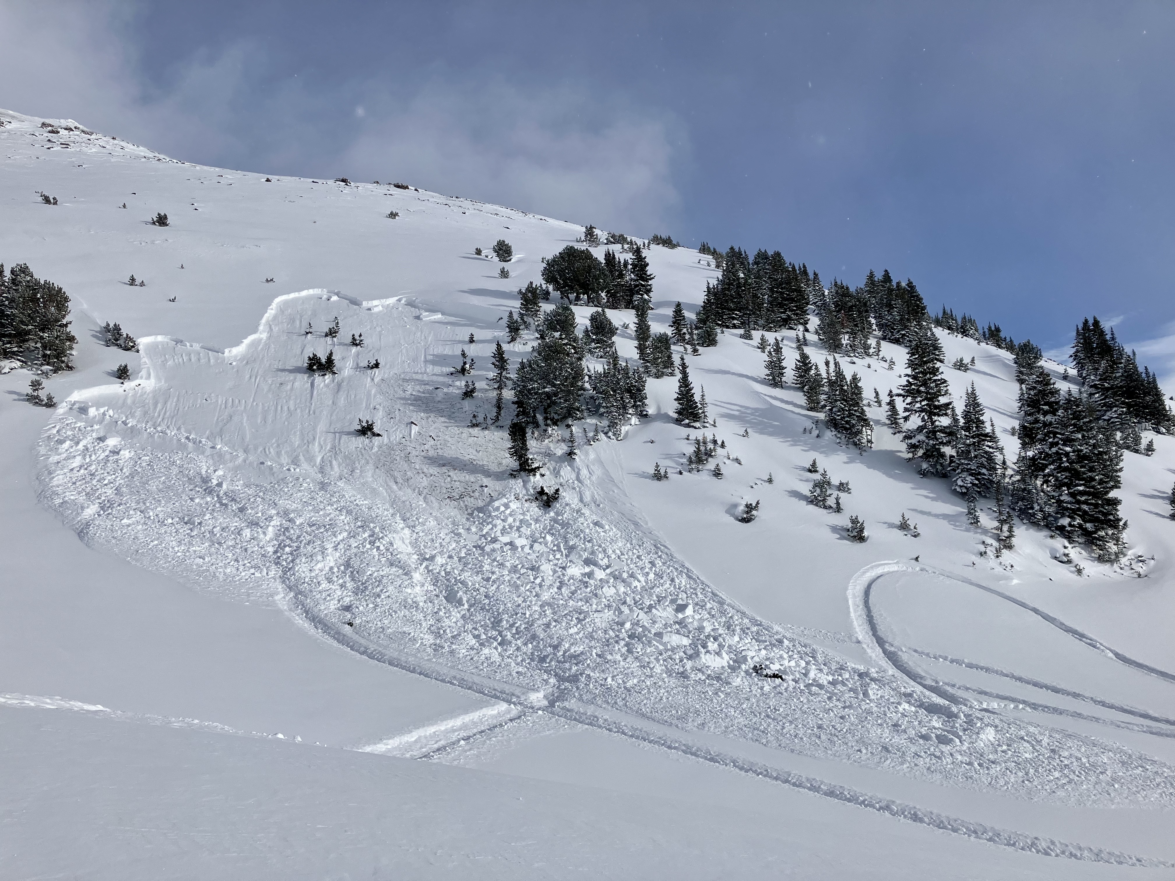
Later we rode over the saddle between Sheep and Scotch Bonnet and saw an avalanche that appeared very recent, and likely triggered by a snowmobiler. It was on a west facing slope at 10,000', and was a hard slab 1-4 feet deep and 150' wide, ran about 200' vertical. AMu-HS-R3-D2-O. This was a clear sign that weak layers exist, especially where the snowpack is relatively shallower, and recent snow has been drifted into thick slabs that are unstable over this weak snow.
Full Snow Observation Report

skied both NE, S and SW aspect lines in Sheep Creek Basin. No signs of wind loading where we traveled, up to 9600’ at the saddle between Sunset and Miller Mountain. There were light winds (M gusts). 8-10” of new low density snow.
Dug a pit on a SW aspect, 8480’:
160cm deep
CT22Q2 Down 40, EctN 25 down 40
ECTP28 down 85
Pole probing confirmed the presence of the top persistent grain layer throughout the landscape, although the associated crust was not widespread.
We also experienced a Whumpf at 45.03667, -109.96733 On a SW slope, 9000’ in a shallow area (125cm depth).
Full Snow Observation ReportSnow above collapsed into the trench from my sled, looked to have broken on a weak layer about 1.5’ down.
Full Snow Observation Report
From email: Dug a pit on a NW aspect near the bottom of Lick Creek. Saw sugary facets 50 cm down from the surface of the snow. Perfromed an ECT and got ECTX.
Full Snow Observation Report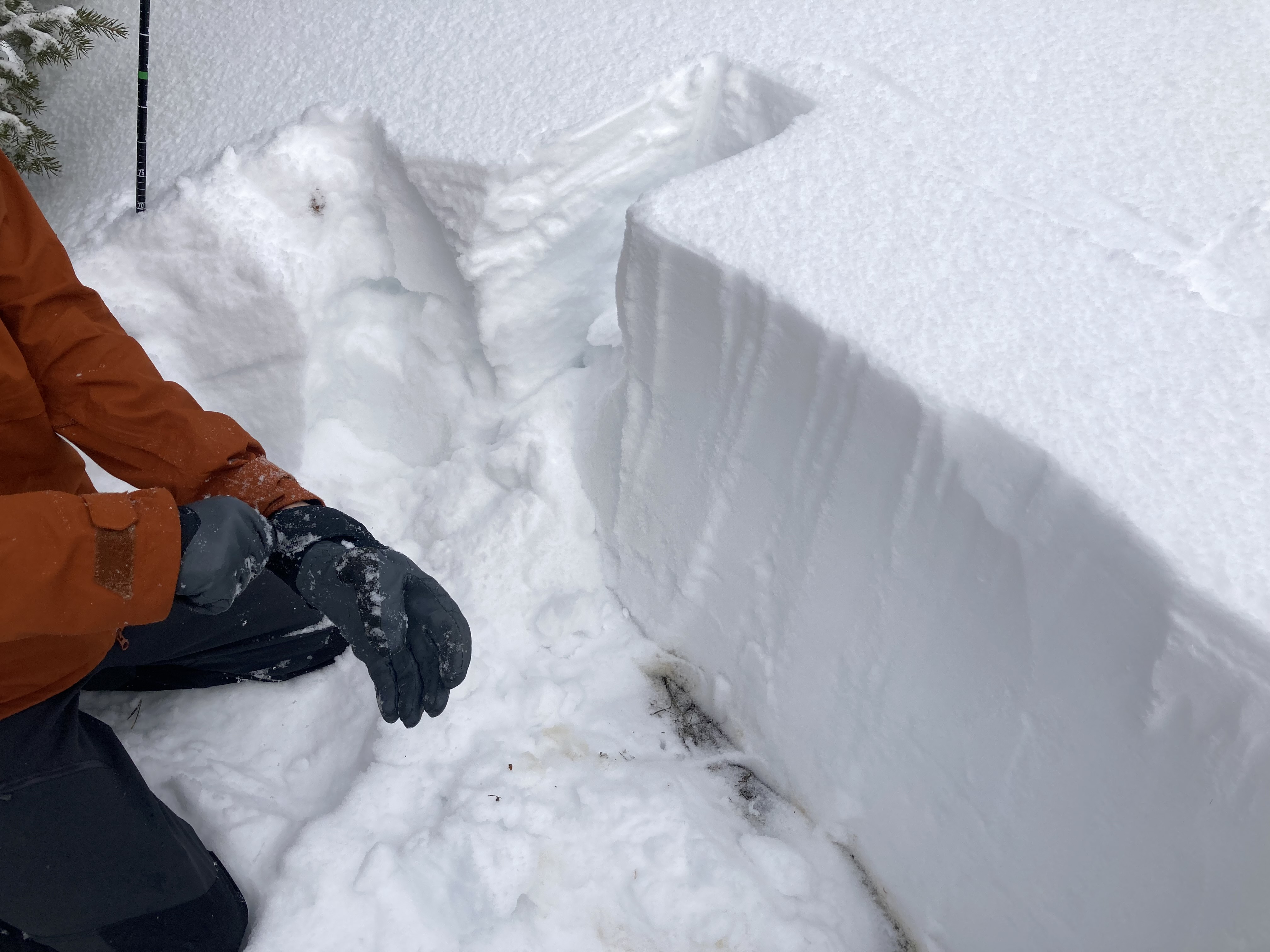
Skiing from Mt. Zimmer Yurt on 12/30 and 12/31, we found two weak layers of small near-surface facets within the new snow at around 30cm and 40cm deep. The layers appeared to be rounding and healing but were somewhat reactive. In our snowpit on an east facing slope at 9,400 feet we got ECTN results on these layers, but in a PST test, the 30cm deep layer collapsed at 30cm into the cut. This made us wary of skiing avalanche terrain and we avoided steep open slopes. We did ski some small isolated steep terrain features and occasionally had this storm slab break off underneath us, but it did not ever propagate beyond steep, convex features such as spines and pillows.
The attached photo shows a small snowboarder-triggered avalanche from 12/31 on a southeast facing slope at 9,000 feet that broke on the 30cm layer and stepped down to the 40cm layer. The intermittent sun on 12/31 seemed to be increasing the reactivity of the storm slab on sun-exposed slopes. The snowboarder was briefly caught in the sliding snow but maintained his footing as the snow washed past him.
Full Snow Observation Report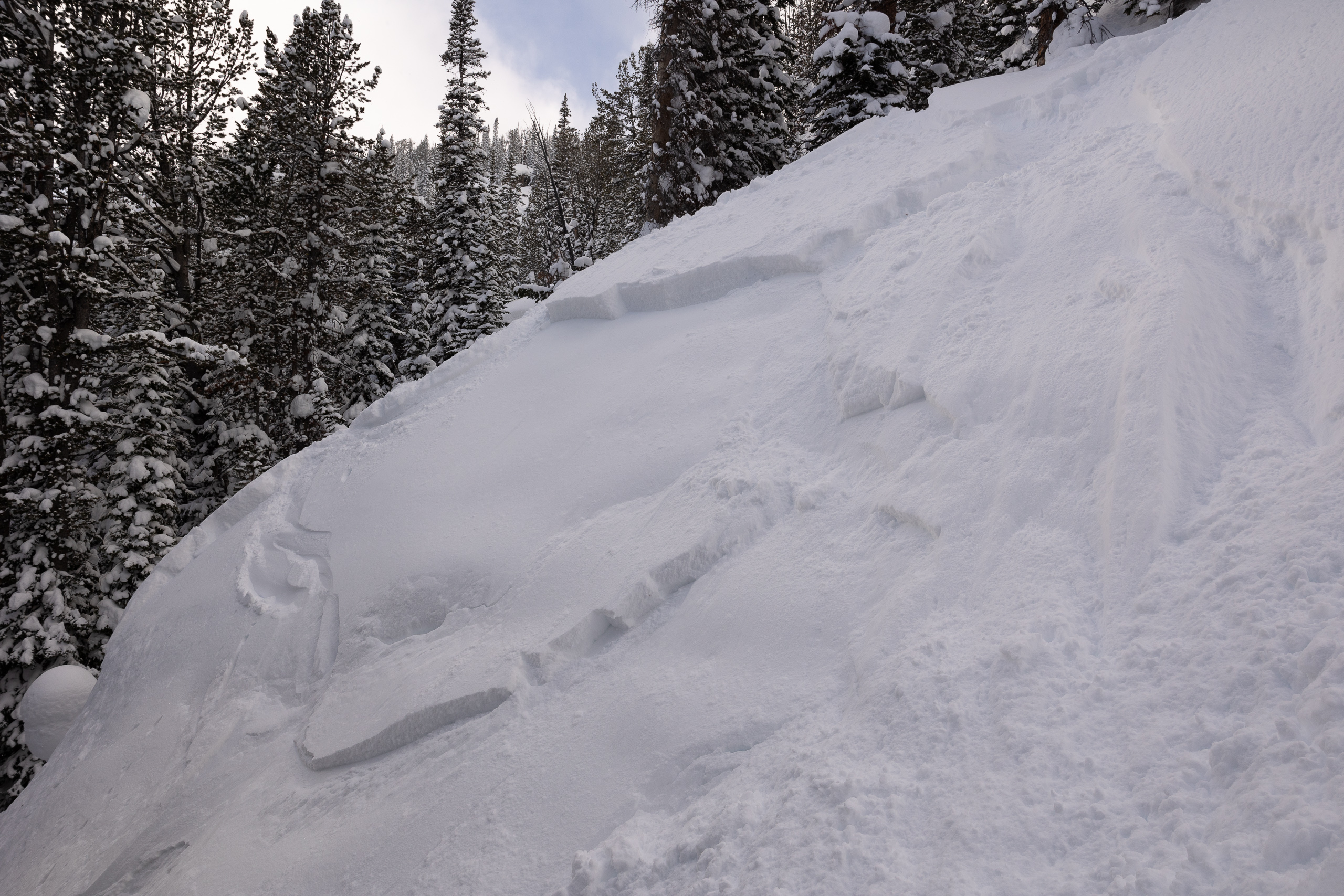
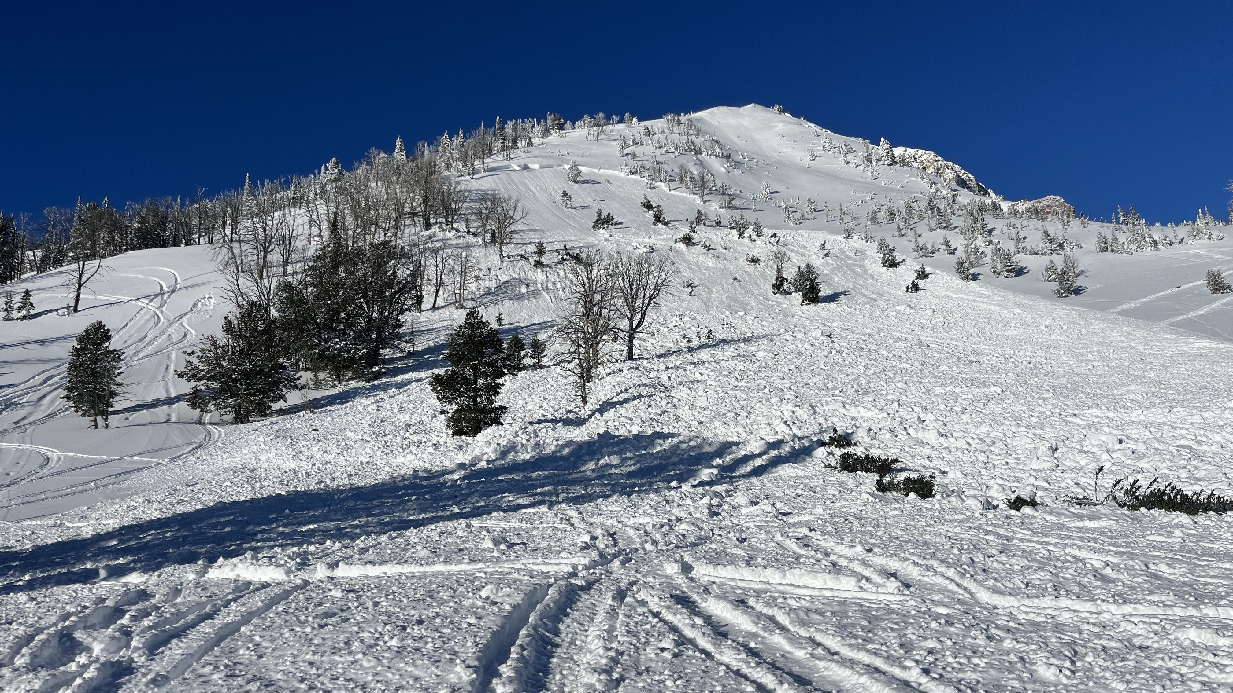
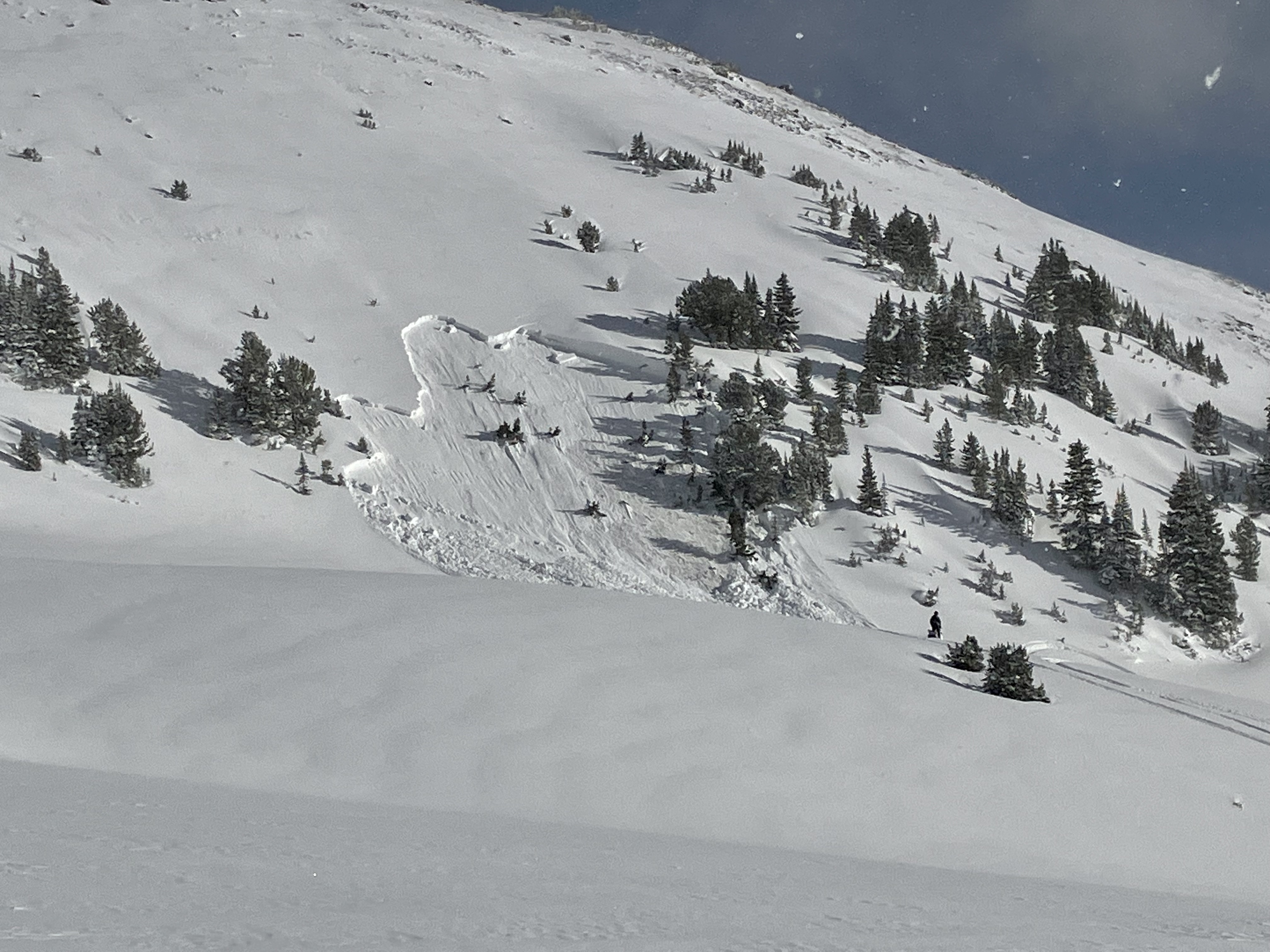
On the way back to Lionhead. Came upon this recent avalanche. Rushed up to the group of 4 guys. They were fine, not the guys who set it off. The group of 6 we passed going there set it off. The group of 4 said they saw these guys ... all on the hill at same time, stuck and climbing around the stuck guy. All were okay but I hear one guy was shaken up. 4-5ft deep at break by 200-300ft wide, ran 400+ft.
Full Snow Observation Report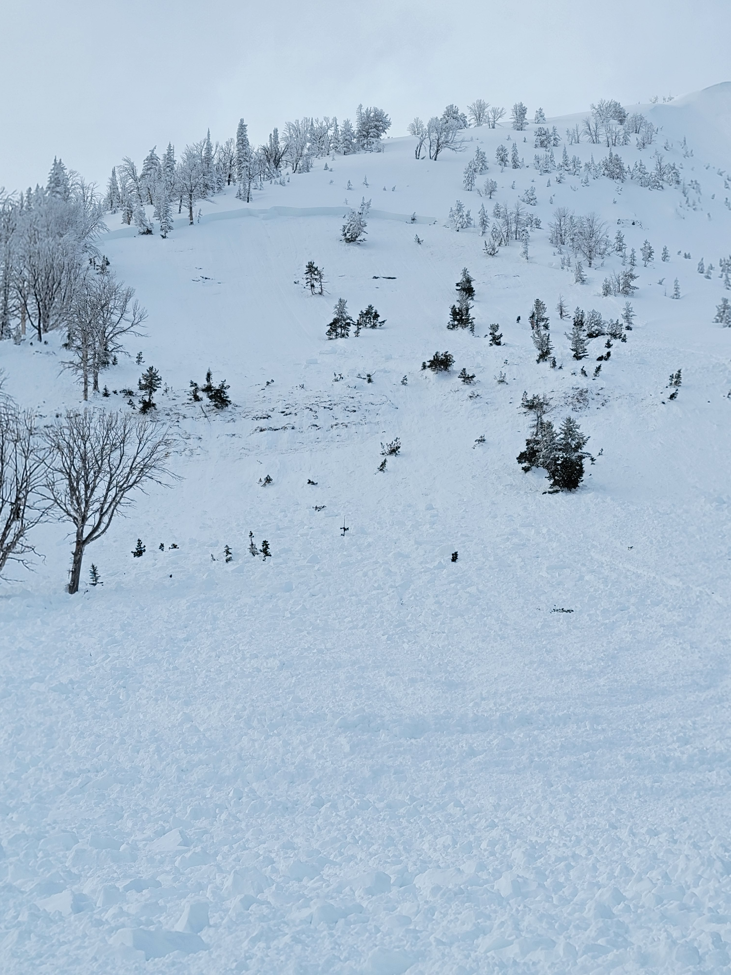
Today we toured up above Blackmore Lake to ski a E-NE facing meadow. We observed about 5-10cm of fresh snow in the area with minimal wind loading. On South aspects, the recent sun crust was much more supportable than in more shaded and protected areas. There was evidence of past wind loading at our pit location, which was on a slightly more north-facing ridge than the meadow we skied. Although this recent crust was evident on all aspects, it was quite soft and breakable on protected aspects. An ECT test revealed instability above a crust layer at 130cm in the snowpack (ECTN22@130). The shear quality was clean at this interface and, when the shovel was placed behind the block, it popped off quite easily. With the significant temperature shifts adding some complexity to the snowpack, it will be interesting to see how the stability progresses at these crust interfaces.
Full Snow Observation Report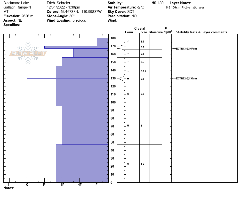
Toured into middle basin and middle peak today. 5-6 inches of new snow. Temps in the high 20s. Wind E and NE - moderate at ridge top. No obvious signs of instability throughout the tour. S1 graupel falling at 1430.
Full Snow Observation Report