Snow Observations List
My partners and I began a tour today at Hyalite Reservoir with a plan to ski the E and N faces of Mount Blackmore, but with the mindset of keeping expectations low and moving slowly giving time for observations and discussion.
On our way in, just off the trail in an opening in the forest at 8600' on a NW aspect with an incline of 29 deg we chose to dig a test pit mostly to see if a faceted weak layer might be present on the shady aspects we were planning to ski. The pit showed a fully right side up snowpack with the snow progressively going from F hardness new snow to 1F snow towards the ground and a depth of 110cm. The snow was not wind loaded on the surface at our pit location and our ECT yielded an ECTX and no obvious signs of instability. As we climbed towards Blackmore and subsequently ascended the NE ridge, there were occasional gusts on the ridge that were actively blowing snow. The ascent towards the Blackmore summit only presented small shooting cracks and considerable cohesiveness in the surface snow in an isolated pocket towards the summit.
We opted to ski both the E and N faces and did not notice any instabilities while skiing the lines themselves.
Full Snow Observation ReportSkied Mt Blackmore today. Dug a pit at 9550ft on a SE facing, 23deg, slope adjacent to the standard east ridge up-track. HS150cm. No wind effect on the surface.
Had a CTE and CTM on density changes in the top 40cm, ECTN on the same layers.
Pulling the CT block into the pit, the bottom 100 cm was very well bonded and pulled up dirt from the ground with it.
Skied numerous laps, and did not observe any signs of instability. The skiing was excellent.
Full Snow Observation Report
Didn't see any windslabs yet on NE facing burn scar. Just like ~2ft of loose fluffy snow. Trees still have snow on them, so wind probably hasn't been that bad.
Full Snow Observation ReportI got out for a low-angle morning lap with some good folks this morning on Little Ellis and thought I'd send along a couple quick take homes:
1. We found 6 ~ 12" of new snow on our way up (and it skied excellently)
2. We saw no obvious signs of instability (cracking, collapsing, or recent avalanches)
3. We observed no wind during our outing (630 - 830am) and found no wind affected snow
4. Temperatures seemed inverted with slightly warmer temps at ridgetop vs. cool air pooled at the trailhead
5. Dug a quick handpit at the top transition and found a supportable pencil hard crust underneath the new fallen snow with well-developed large-grained facets below that... but the quick hole was in the upper scree/rock garden... so I'd expect it to harbor more basal faceted snow.
Full Snow Observation ReportI thought this would be interesting to share but while driving around Gallatin gateway today I noticed multiple small wind pockets that released in steep draws in the gateway foothills area.
Full Snow Observation Report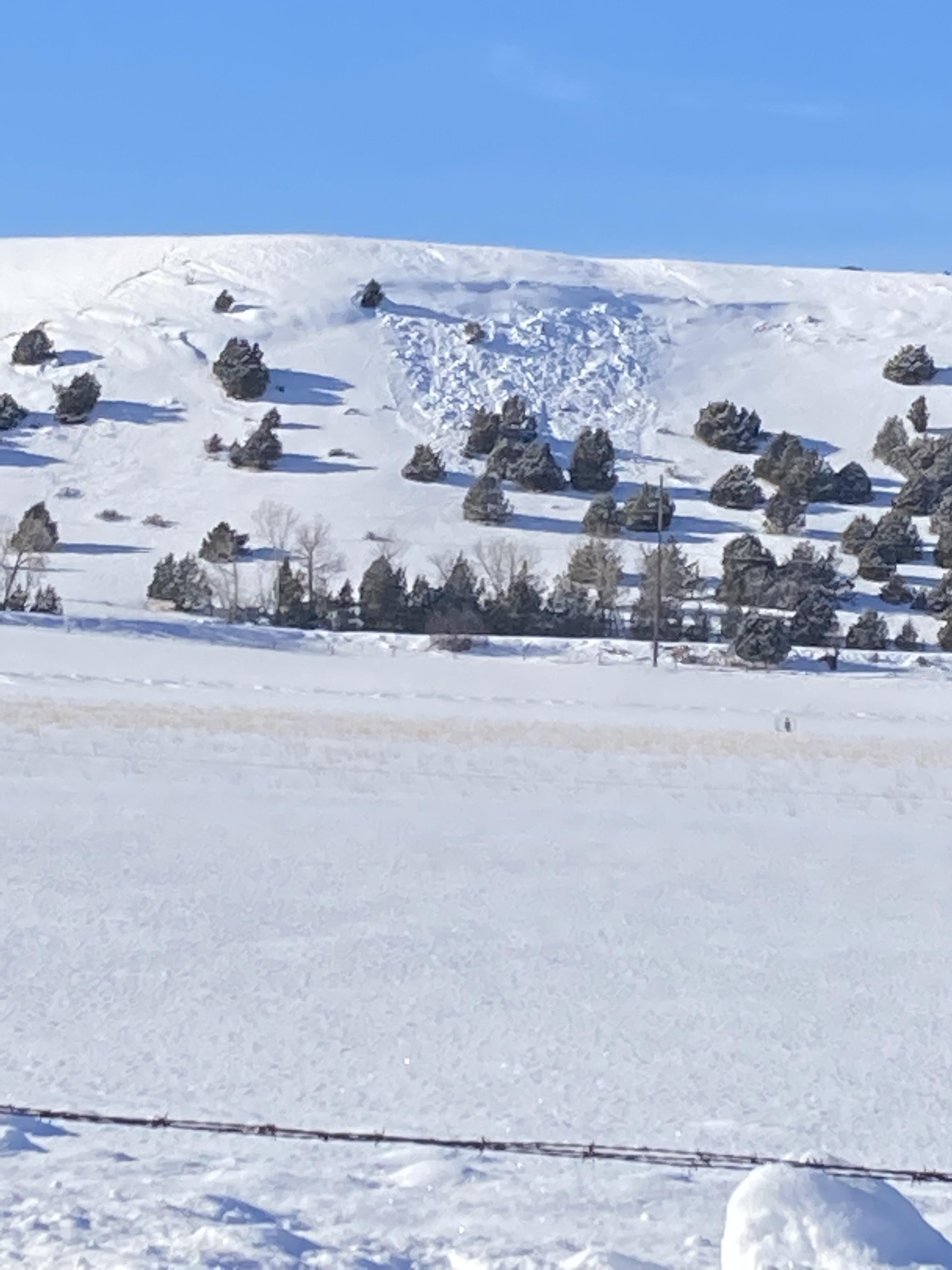
I skied on the N/NE facing side of Dudley twice this week, once on 12/13 and again today. On Tuesday we found HS to be no more than 90 cm with the lower 40cm or so being 1-2mm faceting DFs turning to all facets by the lower 20 cm. Seemed similar to the layer that’s being discussed further south but lacking any sort cohesive slab above it (ski pen was mid-pack, boot pen to the ground).
Today there was no more than 15 cm of new snow with minimal wind transport. Surface hoar was widespread even near the ridge line. We experienced one localized collapse on our up track at around 8000’, so seems like this little bit of new load is just starting to tip the scales.
Full Snow Observation ReportI got to the top of the south summit around 11am with lots of active wind loading. I traversed the ridge line for a couple hundred feet, kicking away at small cornices to see if I could trigger anything. Got two small 6-8” deep soft slabs to propagate 10’ wide and a couple hundred vertical but nothing major. The ridge line is too rocky to traverse right now so I dropped onto the face, still staying near the ridge line. A hundred feet or so further across my traverse, it got deep. Cross loading from the north grew a drift that was thigh deep at least. Very cautiously I tried to regain some elevation to get above anything that might pop off. A few steps up the drift, I heard a whumph and it started to slide. I would estimate 2-4’ deep, 150’ wide. It immediately caught my skis and started taking me down. I pointed them down hill and started to pick up speed hoping I could cut out of it. It started getting very deep and turbulent so after 200-300’ I pulled my airbag, while still trying to stay on my feet. Thankfully, I was able to stay up and cut out of the slide roughly 500’ below the summit. It ran full length into the bottom of Argentina bowl and south gut with a massive powder cloud. Way too close of a call. I skied down the avalanche path then back to the resort with my airbag deployed in case of any other slides coming down. Made it back to the resort touched base with ski patrol to alert them of the slide, give them information on my condition and the possibility of other skiers out there (no possibility, I was first person up and didn’t see anyone ascending from the gate when I crossed to south summit) and headed home.

Dug in 1st and 2nd Yellowmules. Found 3-4 ft of total snow with 1.5 ft of 2mm facets at the ground in both pits. Fist-plus hardness. ECTP23 & ECTP24. The structure looks similar to what we've been seeing in the S.Madison and Lionhead area. This is the farther north we've found the thick layer of facets and makes us suspicious it might be in other areas north of Big Sky.
5-6” new snow. New snow was somewhat drifted, but not intensely.
Saw a small (R1D1) wind slab avalanche along the 2nd Yellowmule Ridgeline. ~20 ft wide, 1 ft deep, and ran 100 vertical ft. Looked to be wind drifted snow that broke yesterday.
Full Snow Observation Report
Via IG Comment:
Full Snow Observation Report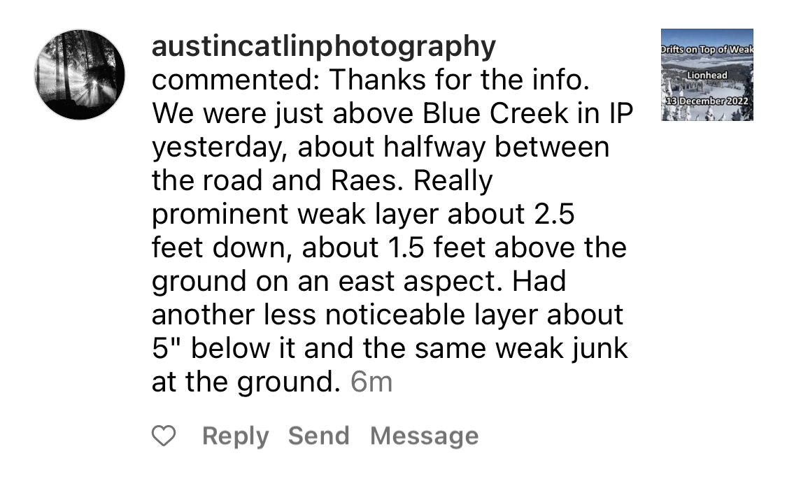
Since Buttermilk is closed for the season we decided to park in town and ride for 20 min. Dave had a large collapse that he heard and felt in a meadow at 8,200 feet. On a NE facing slope off Lionhead Ridge we found 135 cm of snow which was basically 2 layers: 1.5’ of facets capped by a 2.5’ wind slab. It broke with a ECTP26. Structure was not great, and coupled with the whumpf we would not feel comfortable getting into avalanche terrain.
Full Snow Observation Report
Paraphrasing from a text from Six Points Avalanche Education:
We dug in the 2nd Yellow Mule. Wind slabs were the primary problem and we were getting consistent ECTPs in the mid 20's on wind-loaded slopes. If the slope did not have a wind load, the slab was missing.
Full Snow Observation Report
We toured up Bacon Rind to the meadow just south of the skillet. We got a whumpf within 5 minutes of leaving the car and another 5 throughout the day. This told us that the snowpack was unstable and would have kept us out of avalanche terrain regardless of our snowpack test results.Snowpack was generally 3-4 ft deep with ~18 inches of facets at the ground. Dug right where we left the valley floor at the site of our first whumpf (7,100 ft, S aspect) and again again at the top of the main meadow (8800 ft, E aspect). 3 ft of snow in both pits. ECPT18 & ECTP17 on 2 mm fist hardness facets in both pits. This weak snow is unfortunately going to be a problem for quite a while.
Full Snow Observation Report
Sw aspect
7900ft
70cm snow depth
Failure/propagation at 20 cm upon isolation in both CT and ECT on facets at the ground
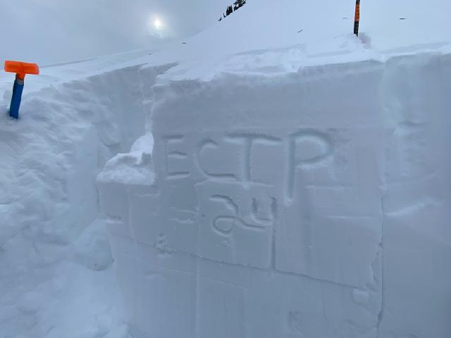
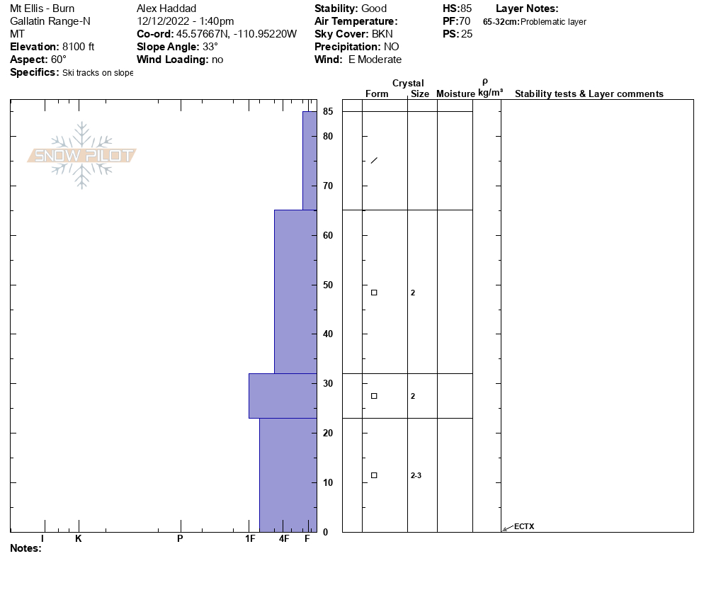
Full Snow Observation ReportWe skinned up to Mt. Ellis summit today. We dug our first pit on the approach at 7,700’. The first pit on a NE aspect was thin (HS = 80 cm/2.5 ft) with an ECTN 11 and 22 in the top half of the snowpack. In this shallow snow we saw depth hoar and facets at the ground. We dug our second pit near the Burn below the summit of Mt. Ellis (8,100’). This NE aspect had 2-3 ft of snow (85 cm), and we had an ECTX.
Both pits showed a shallow snowpack with facets at the bottom. Moving forward, the thin snowpack will be more susceptible to faceting. Also, the poor structure of this snowpack (dense snow on top of facets) could be a concern with more snow. These two things show us that we should continue to assess the snowpack around Mt. Ellis.
Full Snow Observation Report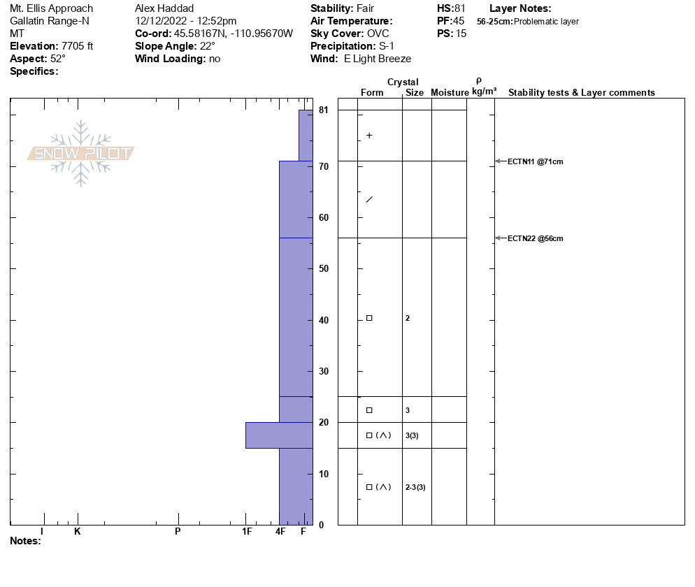

We hiked the ridge to Football Field. We dug just below the ridge and found a couple of problems in our pit. A 15-20 cm (6-8”) wind slab had formed over the last few days. The HS was 110 cm, and we got an ECTP12, below that wind drifted snow (11 cm down from surface). Next, we got an ECTP 21 and 28 in the middle of the snowpack (56 cm down from surface). The ECTP21 and 28 occurred on 1-2 mm facets sitting below a pencil hard layer of rounded grains.
Full Snow Observation Report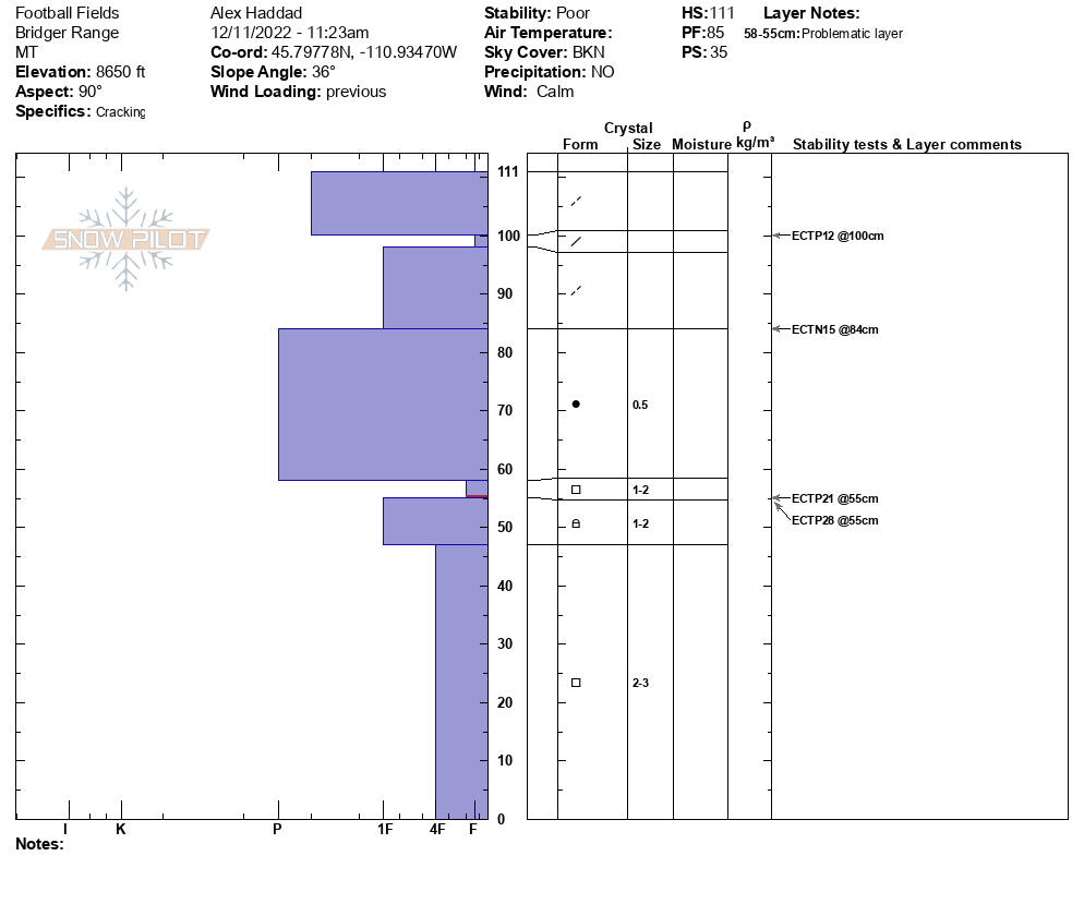

Large slough or slide in Hyalite today. Taken from Lick Creek. Looks like either land of the lost or avalanche gulch
Full Snow Observation Report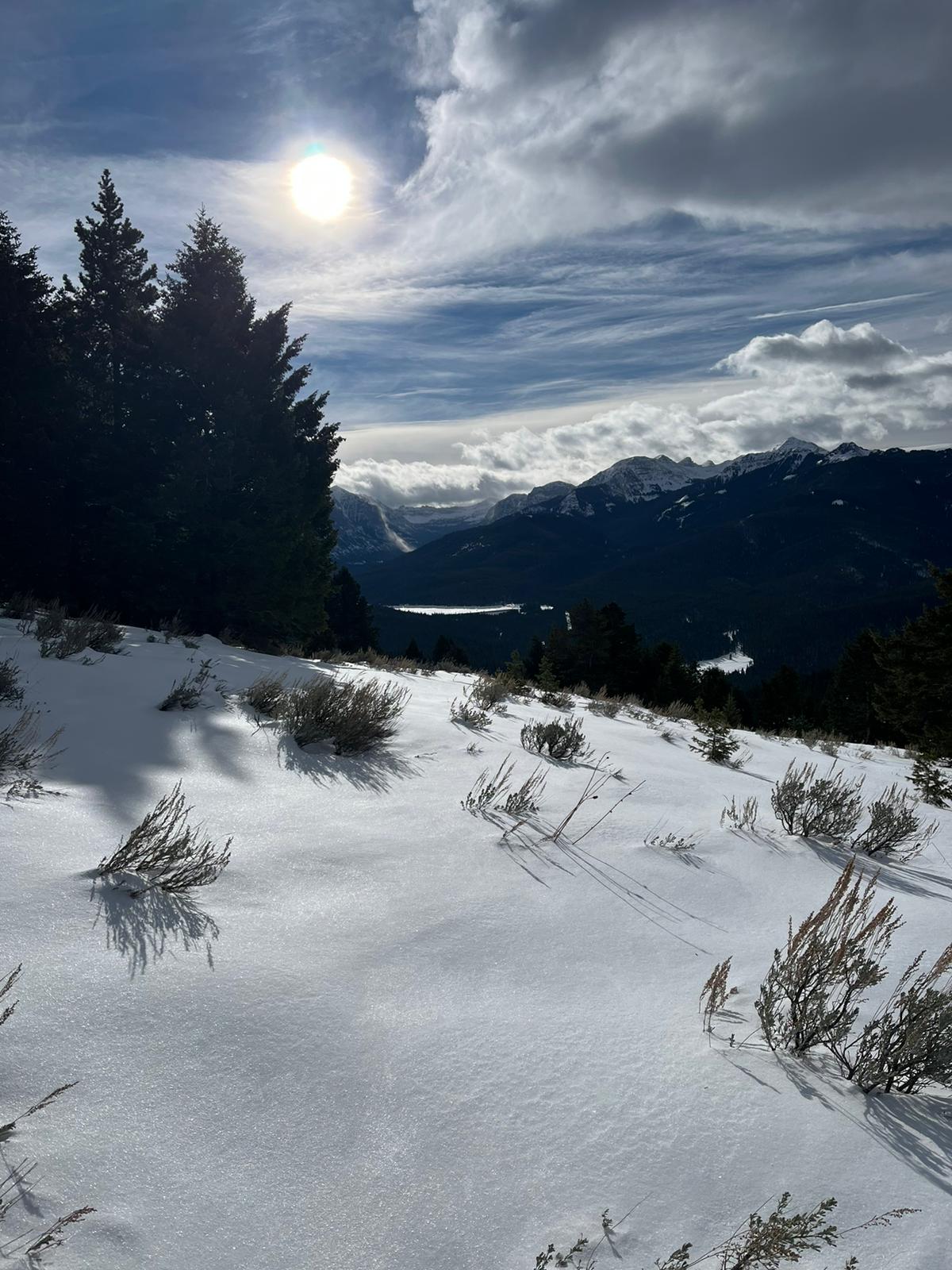
No unstable results in 12 pits, dug on E-SE and W aspects at 8600’. HS 125-140cm. Light to moderate winds out of the S, with strong ridge top winds overnight. No cracking, collapsing, or other signs of instability. S-1 throughout day.
Full Snow Observation ReportMy partner and I snowmobiled into the Taylor fork up to the base of Shedhorn Mountain where we began ascending the E aspect on skis. On the way up, SW winds were gusting in the moderate range and there was active wind loading visible on the ridgeline. We chose to make our way up one of the main avalanche paths and observed a definitive faceted weak layer below more recent new snow. In November, I had observed this weak layer while it was forming, so I was not surprised to find it.
On a due east aspect at 8972', we chose to dig a quick test pit in lower angle terrain before traveling higher on the slope and exposing ourselves to the steeper avalanche terrain above that had evidence of somewhat recent D1-1.5 avalanches. Our pit showed a snow depth of 80cm and a definitive weak layer below recent new snow. Our results were encouraging, ECTN16, and we skinned up to treeline and skied the lower angle slopes below.
Full Snow Observation ReportWe took our Avalanche Awareness class up to Bradley today. We ascended up the southern flank of the meadow, and at about 100' below the top, we headed south just adjacent to the main meadow (lat. long. coordinates provided are at pit location). We fanned out and dug 5 pits. Four of them had an HS of roughly 60-65 cm, consisting of F storm snow with 4F below, the ocassional zipper crust, and then a bottom 15 cm or so of basal facets. ECTX in all of those pits.
For the other pit, we seeked out a wind loaded area adjacent to the other pits.
Elevation 7751', aspect 92 degrees, slope angle - 18 degrees,
HS 110 cm
0-40 cm 4F to 1F
40-80 cm 1F+ to P
80-110 cm 4F Facets
ECTP21 at about 100-105 cm, just above ground within the basal facets
This result was in a very isolated piece of terrain. Stomping around on the wind drift adjacent to the pit location, we saw no shooting cracks nor did we experience any collapses. The stout slab seemed to be keeping us from impacting the week layer until we isolated a column and banged on it with the shovel. It was quite the collapse when the crack propagated in the pit and the slab was thick, hard, and heavy to lift. It makes me curious of how this snowpack structure will respond if/when we put a significant snow load on it.
Just one result, but an interesting one.
Full Snow Observation Report